¤ SILVER SPRINGS LAKES
Silver Springs Lakes
| “A pond is a body of water smaller than a lake... The upper area limits of a pond—and so the lower area limits of lakes—vary considerably between 2 hectares (~5 acres, 20,000 square meters) to 8 hectares (19.768 acres, 80,000 m2)…the now widely adopted definition of a pond is ‘A man-made or natural water body which is between 1 m2 and 2 hectares (~5 acres or 20,000 m²) in area, which holds water for four months of the year or more'”— from Wikipedia. |
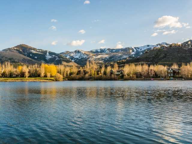
Silver Willow Lake is recorded as 20.84 acres. Water Storage: 140 acre feet.
Silver Willow Pond is recorded as 5.24 acres. Water Storage: 25 acre feet.
(The 5.24 acre pond includes an 1989 deed attachment “Private Exclusive Enjoyment Easement” to the 22 SouthShore subdivision lake view lot owners)
The Silver Springs lakes and ponds were dredged out by Hatchco, owners were Harry Collard and Edward Stewart. For payment they received SSSF Lots 49, 67, and 88.
Mountain Regional-SS-ponds
- 1972 U.S. Clean Water Act -Between 1972 and 1977 the 1948 Federal Water Pollution Control Act was significantly reorganized and expanded then renamed the “Clean Water Act”. After the primary driver for the proliferation of single family homeowners’ associations in the U.S., that being the value to the developers and the municipalities, the secondary driver, the Clean Water Act which required all new real estate developments to detain storm water so that flow to adjoining properties was no greater than the pre-development runoff. This law required nearly all residential developments to construct drainage channels, detention or retention areas to hold excess storm water and run-off until it could be released at the pre-development flow level. Since these detention areas serve multiple residences they are almost always designated as “common” areas. Real estate developers therefore, established homeowner associations to maintain these federally mandated common areas, thereby ensuring an entity, rather than an individual or the local municipality, to have maintenance responsibility. With a homeowner association in place, the developers expanded their scope to provide other requirements and amenities that they believed would help them sell lots and houses. This federal law had a significant influence on the inclusion of several retention ponds aka the Silver Willow “lakes” within the master plan of Silver Springs East aka Silver Springs Master Association.
- 1981 June 8, Water System Development, Lakes, and Water Courses. Includes map.
- 1989 August 2 Private Exclusive Enjoyment Easement runs with the land deeds for Southshore Lots 1-22 and Northshore Lots 1-11.
- 2004 May 25 Lakes Conveyance and Water Supply Agreement signed only by MA Pres. R. Anthony Sands, includes check to MA. Not presented to the Silver Springs Property Owners for their vote, nor for the vote of their representatives to the MA.
- 2004 July 13 letter from attorney Craig Smith with Warranty Deed for Lakes
- 2004 – July 14 recorded Warranty Deed from Mt. Regional to MA
- 2009 – October 20 Noland and Bailey created an affidavit that is denied by some of the listed HOA representatives.
*Silver Meadow Minnow Retention Pond is 0.367 acre.
(Deeded on Silver Meadow subdivision common area.)
**There is a very small private retention pond on Lot SLS-C-173
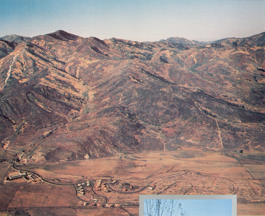
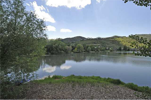
| Silver Springs East – In photo above, the first homes built c. 1979, before lakes were dredged. c. 1980 – The Upper and Lower Ponds are beginning to be dredged by Hatchco. The $1 million contract with Harry Collard and Edward Stewart was paid in part with transfer of title to Silver Springs Lots 49, 67, 88. Seven or eight artesian springs are located in the 20 acre lake bed. The irrigation system is started in Phase 1A and the pump house is located on Parcel “H”. |
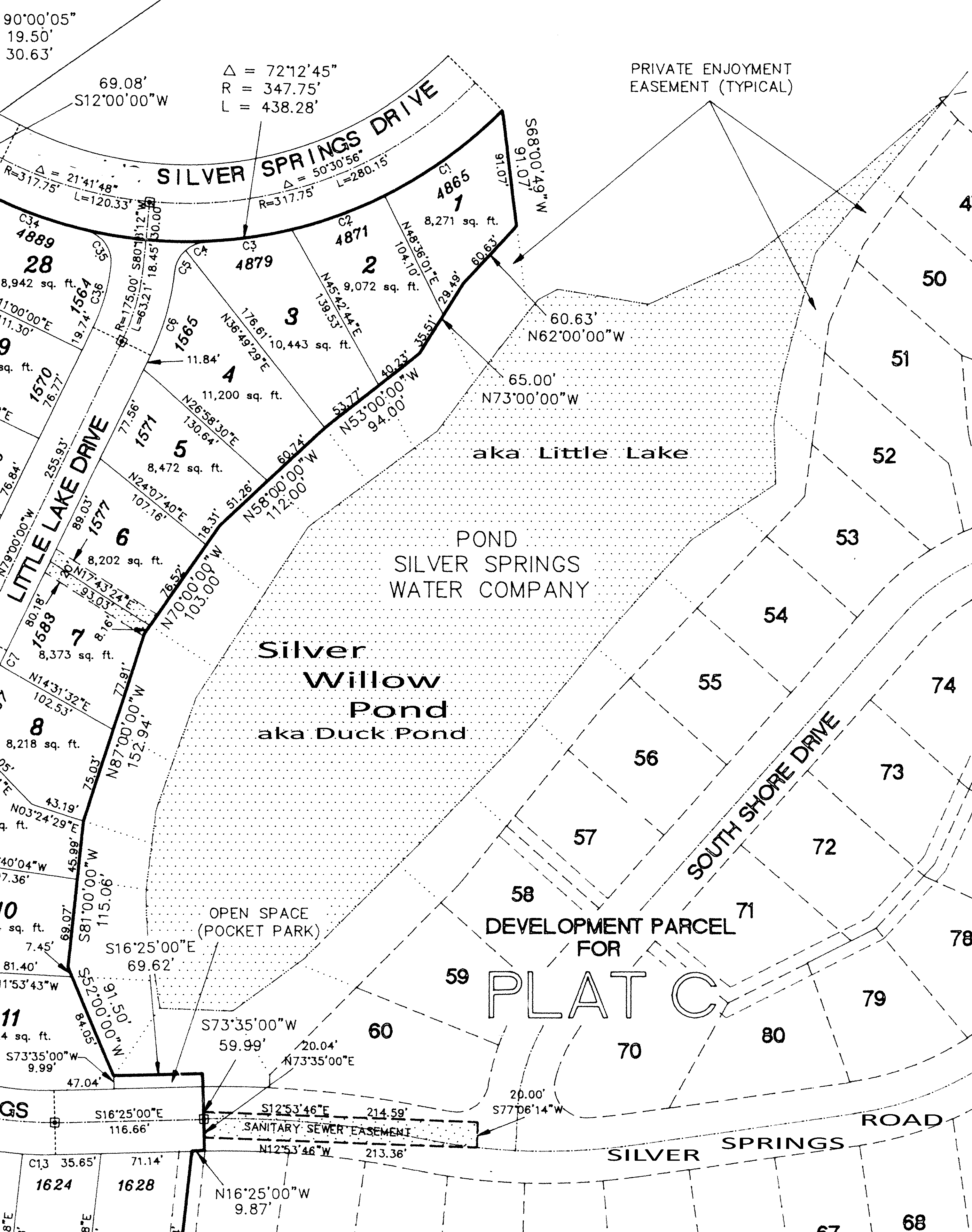
JUNE 9, 1981 MASTER PLAN SILVER SPRINGS EAST
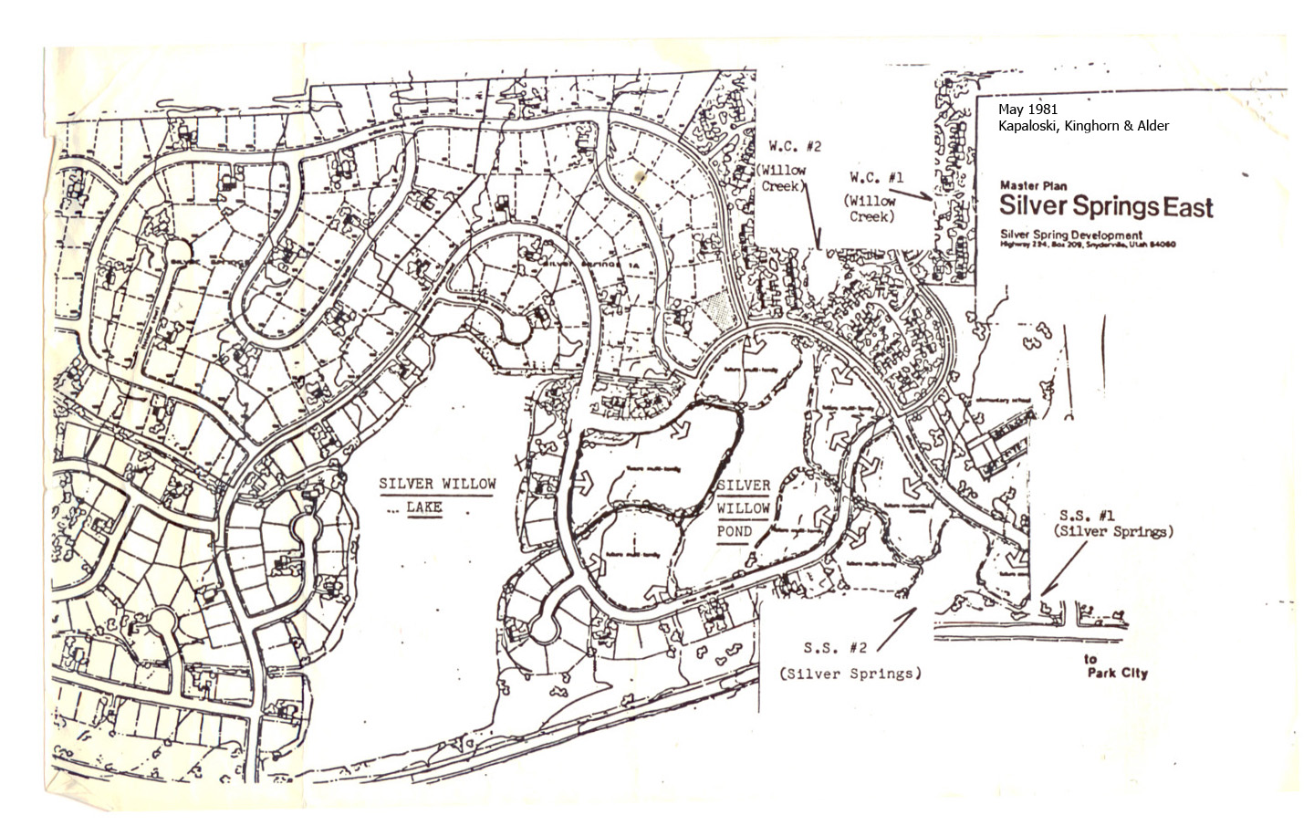
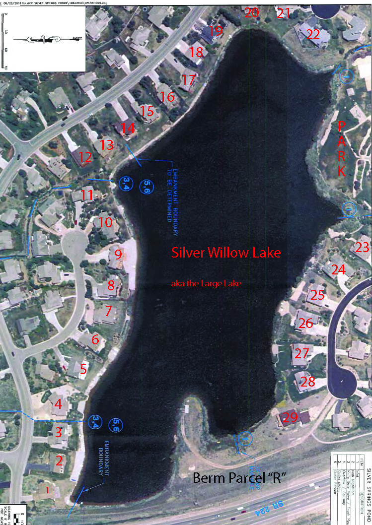
THE BIG POND aka SILVER WILLOW LAKE (PP98-A-10)
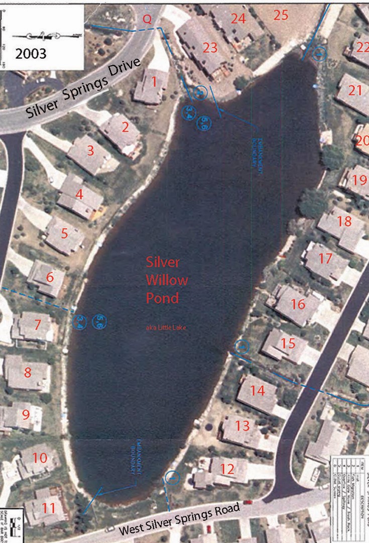
Silver Willow Pond (6510 feet above sea level) and Silver Willow Lake (6480′ ft above sea level)
Note that Silver Meadows Townhouses, Quail Meadows Condos
and Willow Bend Village are in photo.
The north side (right side) of both lakes shows the built up areas now known as the “dams”
= NorthShore Lots 1-12 and SouthShore Lots 1-13.
c. 1988 EMERGENCY ACTION PLAN – Silver Creek Spring Ponds
| Waterways in Silver Springs c. 1994 – Silver Willow Lake on top, Silver Willow Pond in middle, Silver Meadow Minnow Pond bottom right (between Meadow Spring and Silver Meadow). These lakes are unique as they are among the few in the United States that are man-made and in private ownership. Others are Fishhawk Lake in Oregon, a lake in Wyoming….managed by Galen “Buck” Buchenroth . International man-made lakes include: Keukenhof, Netherlands |
See Silver Springs Dams webpage.
For information on the Enjoyment Easement refer to this websites
—ENJOYMENT EASEMENT page
Also see: https://www.silverspringscommunity.com/master-association/ma-common-area-parcels/parcel-w/
|
CORRESPONDENCE WITH THE UTAH DIVISION OF WATER RIGHTS Utah Administrative Code… is the body of all effective administrative rules as compiled and organized by the Division of Administrative Rules Title R655 Natural Resources
|
Shown above in yellow are 15′ to 25′ foot wide “Enjoyment Easements” around Lakes
that are either fee titled to Silver Springs Development Inc. during the late 1970’s
or else are unowned easements perhaps deeded to Silver Springs Association in the 1980’s. The Exclusive Enjoyment Easement around three-quarters of the little pond was deeded by Barnes & Widdows in 1989 to the contiguous property owners only. Unfortunately, the Master Association erroneously continues to charge non-owner SSMA property owners for the maintenance, repair, taxes, insurance, and management costs for this private pond and easement.
– drawing c. 1980 by J.J.Johnson Engineering.
| Summit County Property taxes for the ground from the back lot lines of the lake view lots, all the way underneath the lakes, then up to the opposing bank lot lines, is prorated to all Silver Springs Community residents on their annual Property Tax bills. The Enjoyment Easement is between 15′ to 25′ wide, and around the entire perimeter of the Lakes. |
INTENDED LAKE USE AND ACCESSOn July 9, 1981 the attorneys for SSD, SSI, Dale Perkins, Mike Hardman, Jim Webster, George Triggs, Roland Palmer and Dick Pearce wrote a File Memorandum regarding the Silver Springs Water Distribution System and this description, “Silver Willow Lake – is a medium size irrigation storage, flood control and aesthetic feature downstream from Silver Willow pond”. Quote: “Silver Springs Water Company will own and control the lake and surrounding recreation facilities. All use of the lake will be dependent on regulations and use agreements between the Homeowners Associations and Silver Springs Water Company…. Each pond and the lake are owned and controlled by Silver Springs Water Company. A property line will be staked showing the buffer area [Enjoyment Easement] around the lake and ponds (approx. 25ft.) and on either side of each water course. Silver Springs Water Co. owns and controls each pond, the lake, each water course and surrounding lands. In the townhouse common areas and the commercial area, Silver Springs Water Company will contract with the Homeowners Association for maintenance of the buffer areas around the ponds and the water courses. Silver Springs Water Company will be responsible for landscaping and maintenance of water course areas through the common area around Silver Willow Lake, through the single residence subdivision and adjacent to the State Highway.”….End Quote.
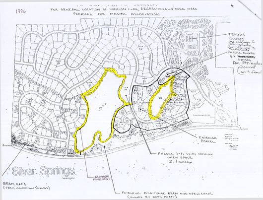
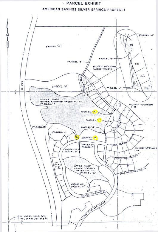
When Silver Springs was first platted and developed the HOA membership had access to the approximate 4,222 feet perimeter of the SS Large Lake (Lower Pond Parcel F Silver Willow Lake) through Parcels H, I, J, K, L, Q, R, S. (See drawing above). Lower refers to the lower elevation of the big lake, though it is north of the smaller lake it is “downhill” from the smaller lake. Stream flow is from the Upper Pond (small lake) to the Lower Pond (large lake). All homeowners had the right to walk the entire perimeter of Silver Willow Lake (Lower Pond on plat) and the stream paths to enjoy the man-made amenity and the flow source in our subdivision. The original homeowners made their decision to buy in Silver Springs with these waterway features in mind. As homeowners moved into homes being built around the lake they added boat docks, ramps, etc. for their private use, though their property lines ended approximately twenty feet short of the waterline. The registered owner of the lake, Silver Springs Water Co., was concerned about the liability issues involved with safety, and water quality for swimming and other water sports being participated in by the perimeter residents (which now also includes ice skating and hockey). Many concerns existed on the appropriate and legal use of the “Lower Pond”. In the mid-1980’s Jan’s Sports taught wind-surfing on the “Lower Pond”. On one occasion over fourteen wind-surfers were skimming on its surface. (Does anyone have pictures?) |
American Savings July 1985 Silver Springs Waterway and Access
Parcels Plat. Several owners went into bankruptcy.
Am. Savings took over parcels belonging to InSource, Hazelwood, and others.
Robert Larsen and Silver Springs Water Co. maintained the water rights.
|
|

1986 –Lake Use I.D. Card – Bill Ligety’s No Trespassing sign:

1988 – June – Silver Springs Water Company Newsletter written by Lynn Stevens, Manager.
1988 – June 21 – Letter to American Savings regarding lake access and park development.
1988 Bill Ligety (Lot 193) and a committee of lake perimeter property owners retained an attorney to assert their sole rights to the lake view property Enjoyment Easement. Sometime during this procedure the lake access Parcel K next to Lot 193 and beach Parcel I west and contiguous to Lots 47, 48, 49 were absorbed into these respective lots. Park Place Lot 44 inadvertently may have absorbed Parcel B or 8. This action resulted in the HOA General Membership losing its right of access (a prescriptive easement) to the perimeter of the Silver Willow Lake, and limiting the general access to 443 shoreline feet of Parcel H (now the Silver Springs playground park area), to a sliver of Parcel J (on the west side of Park Place), and to the berm and pump house Parcel R (a portion which possibly may belong to Mountain Regional Water Company). Parcel K aka Tax I.D. Parcel Number PP-98-A-2-A Entry 00298852 Book 497 Page 280 Recorded on October 17, 1988 was deeded by American Savings & Loan to William C. Ligety and Cynthia Sharp.
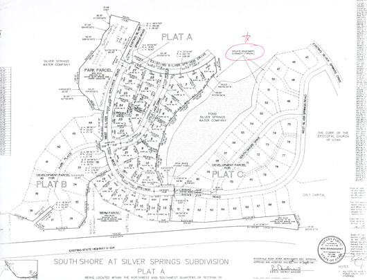
In 1989 the developers of SouthShore received from the Silver Springs Water Company the exclusive rights, use and access to the Silver Willow Pond, a.k.a. Little Lake, via a Private Enjoyment Easement Agreement. The 1991 recorded SouthShore plat reveals that the Little Lake is for the exclusive use of the Water Company and the 22 lake view property owners. The deed to the easement property was never transferred from the original developer, SSD’s name is the first developer-owners around the 1970’s.
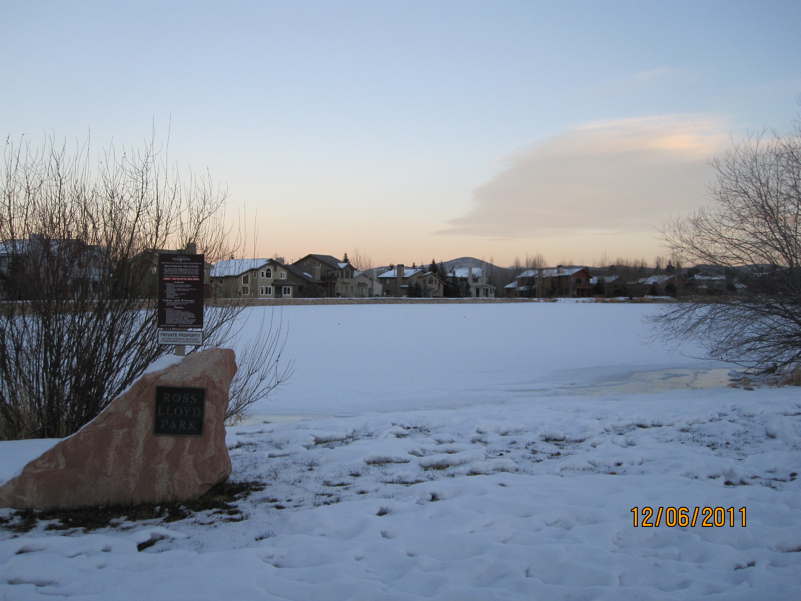
1991 South Shore Plat A – shows the Silver Willow Pond a.k.a. Upper Pond, survey parameters with the “Private Enjoyment Easement” around the entire perimeter. An Agreement dated August 1989 gives “purchasers of residential lots bordering the Silver Springs ponds (the “Lakeview lots”) the exclusive private enjoyment of the Shoreline Property adjoining their respective Lakeview lot.” At the top of this plat (east section) are the six lots belonging to Silver Springs SF at Little Lake subdivision that did not belong to Barnes and are not covered by his 1989 Agreement. The Ross Lloyd pocket park on the west corner lies along Silver Springs Road, outside of this Private Enjoyment Easement therefore, for this second reason, the majority of the SSMA Members do not have access to the Upper Pond aka Silver Willow Pond nor the Private Easement. The Master Association continues to erroneously charge non-lakeview lot owners for maintenance, repair, taxes, insurance, and management of properties they have no legal ability to use or access.
SouthShore at Silver Springs 1991 Plat
This 70′ X 10′ Pocket Park is located outside of the 1989 “Exclusive Private Enjoyment Easement” as an Open Space. It is located along Silver Springs Road, recorded as a SouthShore subdivision property not a Master Association common area parcel. In either case this Park does not provide legal access to the Silver Willow Pond by non-lakeview property owners..
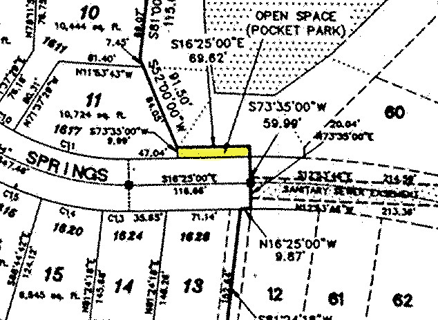
The Ross Lloyd pocket park (10′ X 70′) on the west side lies along Silver Springs Road and outside of this Private Enjoyment Easement. The pocket park is not contiguous to the pond therefore the SSMA Members do not have legal access to the Upper Pond aka Silver Willow Pond although they are erroneously charged by the Master Association with payment of the maintenance, repairs, taxes, insurance and management of this pond and private easement.
1995, May 5 – Silver Springs Water Co. presentation to the SSMA.
20 Houses/lots on the perimeter of Little Lake Exclusive Private Enjoyment Easement are platted as the property of SouthShore subdivision.
2003 Aerial of Silver Willow Lake perimeter -29 lake view houses
THE BIG POND aka SILVER WILLOW LAKE (PP98-A-10)
2000 – December – Water Committee:
Ralph Stanislaw – Park Place
Ron Duyker – South Shore
Matt Lindon – Silver Springs
Brodie Pollard – Silver Springs
Mike Washington – North Shore
Jaylene Chandler – Sun Peak
Chuck Hollingshead -Sun Peak
Ron Lockhart – Sun Peak
Craig Smith & Brett Rich – Attorneys from Neilson & Senior
2001– March 19 – MHOA Minutes state: “Our ponds will be part of the Mt. Regional transaction. There will be a separate hearing to transfer the lakes from Mr. Robert Larsen to the Master HOA. The Masters will aggressively move to clean-up the lakes. There is a water hearing at Parley’s Park March 22, at 6:30 PM…”
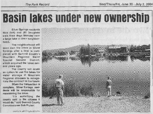
2002 – December 11 – Silver Springs Water Company deeded over PP-98-A-1–A, PP-98-A-6 (Upper Pond or Small Lake), PP-98-A-10 (Lower Pond or Large Lake) to Mountain Regional Water Special Service District.
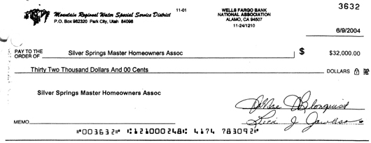
2003 – Mountain Regional Water Special Service District provided a Ponds Remediation Plan indicating the condition of the lakes and equipment, and what they would do before transferring the lakes to the Master HOA. Rather than commencing the work on the Remediation Plan, Summit County issued a check for $32,000 to the Silver Springs Master Association if they would take the lakes “as is”. The cost to raise the Lower Pond up to the standards of the plan became five times more than the settlement amount, plus hundreds of hours of work by Silver Springs volunteers.
2003 – May 19 – Lake Update – “Lake Lease Agreement: Ron Duyker believes that Mt. Regional wants to charge for the use of lakes and streams. This agreement will not be signed. Ron suggested that we reform a lake committee but this time with primarily lake front owners. He thinks that the lake front property owners benefit the most from the lakes. Ron proposed that the Masters pays what frontage we own to the lakes and that lake front owners pay based on their frontage as well.”
2004 – The Homeowners were still in shock about losing their Enjoyment Easement around Silver Willow Lake and the common area access parcels. The HOA Association desired both legal title and beneficial use and member access to the water amenities of the property that encompasses the two Lakes and property with subsequent minor holding ponds and streams, together with the dams more particularly described in Exhibit A, formerly owned by the Silver Springs Water Company. The Mountain Regional Water Company wanted to have the Association assume the responsibility for ownership and maintenance of the Lakes; and reserve the future opportunity to store the District’s water in the Lakes for any future irrigation system of the District. also Mountain Regional and Summit County desired to use the water in the Lakes for fire protection purposes; and at the same time attempt to settle all claims regarding the transfer of the Lakes to the Association, etc. The Board feels that since Mountain Regional uses the HOA land upon which it stores its water that Mountain Regional should be assessed for insurance and maintenance costs. (See April 18, 2005 Minutes.)
The previous owners of the lakes since they were dredged, namely Robert Larsen, SSD Inc, Silver Springs Water Company, Mountain Regional, etc., had performed very little to no maintenance on the lakes since inception around 1980. At the time the lakes were offered to the MA in 2004 they had become “basically cesspools” (a little harsh but you get the idea). The shallowness of the water, the geography and ecology of the land, and the insignificant flow through of stream waters had taken a toll on water quality. The MA participants, Les Carriel, Eric Fraleigh, and others made the decision that they did not want anyone else to have control of these lakes even if “they were two mud holes” in the center of our Community. Feeling strongly about this, but without General Member notification or vote, and without the consensus of all the individual HOA boards, the MA president made his decision to sign the 2004 Lakes Conveyance Agreement.
The State Engineer provided an “Inspection and Maintenance Form for Silver Springs Ponds” for use by the MA trustees.
2004 – June 23 – Silver Springs Master Homeowners Association, a non-profit corporation, and the Mountain Regional Water Special Service District of Summit County entered into the Lake Conveyance and Water Supply Agreement. The only signatures on this document are those of Richard Anthony Sands, then president of the Silver Springs Master Homeowners Association and Ken E. Woolstenhulme, the Chairman of the Governing Board of Mountain Regional Special Service District. There are no records found indicating that this agreement went to the vote of the Silver Springs Master Association General Membership at an annual meeting. The MA is being run as a non-profit corporation as it has not finalized Bylaws or received authority from the property owners or the 8 or 9 HOA’s in Silver Springs.
Mountain Regional Water had hired an assessment report on the Silver Springs lakes to be completed prior to the conveyance agreement. The Klinefelder Engineering firm performed quite an extensive study on the condition of these lakes. The report established that much work was needed to be completed to bring the lakes up to State standards. Mountain Regional offered the MHOA a $32,000 check if the MHOA would assume the responsibility for ownership, repair, and maintenance of the Lakes with the water and water rights being retained by Mountain Regional.
2004 – July 14 – Mountain Regional Water deeded the Silver Willow Lake, land only, (PP-98-A-10 Lower Pond aka Large Lake) and Silver Willow Pond, land only, (PP-98-A-6 Upper Pond aka Small Lake) to the Silver Springs Master Homeowners Association and was accepted under the signature of one member of the Master Association Board. The 508 General Members of the Master Association were not informed or consulted, neither was a vote solicited nor received whether the General Membership wanted to accept the Lakes or their maintenance, repairs, insurance, management, chemicals, seed fish, or their liabilities and potential damages. There were a number of General Members who felt the General Membership would not benefit sufficiently from this transaction. Some felt the lakes should have been deeded to the respective lake view property owners, as they benefit directly. The small lake has a “Private Enjoyment Easement” which precludes its access or use by the General Master Association Members, and the large lake, at the request of the lake view owners, has had its access parcels closed and the “Enjoyment Easement” reduced to the central Park beach area and along the seven lake view homes at Park Place.
With this Conveyance Agreement (was never recorded though it is available at the office of the Summit County Clerk), the MA assessed what the responsibilities entailed. The Klinefelder Report had warned of liabilities if the dams, baffles, gates, and soundness of the outlets were to fail and individual homeowner properties were damaged or destroyed. The condition of the lakes and their infrastructures was very poor. It should be noted that the lakes are generally stagnant bodies of water except at the inlet and outlet streams in the spring. There are no motorized vehicles nor rapid water flow therefore there are no waves beating against the dams. See location of Silver Springs dams.
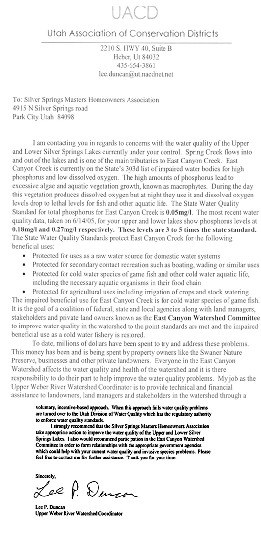
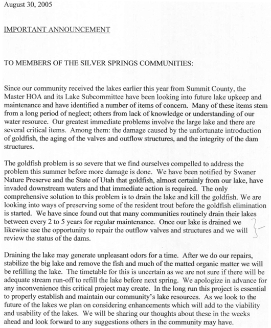
2005 – Spring – The Utah Association of Conservation Districts – Upper Weber River Watershed Coordinator, Lee P. Duncan sent a letter to the Silver Springs Master Homeowners Association. The contact was regarding concern with the water quality of the Upper and Lower Silver Springs Lakes. Spring Creek flows into and out of these lakes and is one of the main tributaries to East Canyon Creek. After testing it was found that our lakes contained 3 to 5 times the state standard for phosphorous and low dissolved oxygen.The Master HOA then began to study the Klinefelder report and the lakes themselves. The Duncan letter was a renewed wake up call regarding the responsibility that had been undertaken as the newly titled owners of these bodies of water (Mountain Regional reserved the water rights to themselves so the water belongs to them. The SSMA actually owns only the ground and the responsibility for what happens as a result of the water), was the SSMA used to off-load a problem the County no longer wanted to be harnessed with? Who negotiated the terms? A plan titled 2005 Goldfish Eradication from the Silver Springs Lakes was set upon and presented to the County Commission. The Lake Committee’s plan was presented by Eric Fraleigh and Les Carriel to the SSMA Trustees but the General Membership was not solicited for a vote. Later some subdivisions sent property owners a notice of work that was to commence. Not all of the subdivisions were in agreement with this plan
The SSMA board, again without a general membership meeting, input or vote, decided to assess each of the 508 properties a special assessment of $220 per Living Unit, in addition to the newly assessed annual fees of $175 per Living Unit, in order to make the necessary repairs on the lake equipment and water quality issues.
2005 – January 21 – Anthony Sands, and attorney Dave Johnson, authored the unvoted upon, not implemented, not notarized, unrecorded 2005 Amendment to the Dev-HOA Agreement which stipulates that dues would be assessed for common area costs as follows:
(i) Condominiums and townhouses ……………………………………………… 100%
ii) Lots, single-family residences and townhouses, without lake frontage: ……125%
iii) Lots and single-family residences with lake frontage:…………………..…… 150%
[The 2005 Amendment should be amended to reflect one of two proposals which should be presented to the General Membership:
First Proposal (based on number of users): Lake view lots are to pay ten times the amount that non-lake view lots or condos pay, this ratio comes from the fact that 50 lake view properties (1/10) directly benefit, whereas the other 454 properties also pay the lake assessments with greatly restricted benefits or access. (According to the Summit County Assessor the only properties that truly benefit from the lake are those that live on its boundary. For example, the Park Place house not on the lake at Lot 35 is listed at $799,000. The Park Place house across the street on the lake, Lot 40 is listed at $1,595,900.)
Second Proposal (based on access perimeter) states that the Silver Willow Lake lake view owners pay 4/5 of the lake costs, the remaining General Membership pay 1/5 of the lake costs. Based on the 80/20 ratio of access available, Parcel H 443 ft + Parcel R & J 470 ft. of the approx. 4300 ft lake perimeter. Additionally, the Silver Willow Pond lake view owners are to pay 100% of the costs for that lake since the little lake, aka the Upper Pond, is privately owned by the SouthShore residents and includes a “Private Enjoyment Easement” excluding the General Membership of access or use of the Silver Springs Community from the Silver Willow Pond, aka the Upper Lake.]
2005 – April 18 – SSMA Newsletter : “Lake Agreement – Silver Springs Masters HOA finally has ownership of the lakes. Well technically speaking we do not really own the water but we do own the ground under the water. For those of you new to the area this is the short version of the lakes. Silver Springs water company owned the ground the lakes are on and every so often they would make claims that they were going to drain the lakes and build condo’s on them. When Silver Springs Water was bought out by Mountain Regional Water the lakes were going to be given to the Masters. This did not happen until last summer with the help of Eric Fraleigh and Les Carriel and Summit County Commissioner Bob Richer. We are currently working on long and short term goals for our lakes to ensure their future.”
2005 – May 18 – Letter to Lake Front Property Owners from Anthony Sands, President of the SSMHOA: “As I am sure you all know, the private property owners on the lakes do not own the property that contains the lakes, or the lakeshore. The lots in different subdivisions have different setbacks from the lakes. In all cases however, the Master Association owns the ground under the water and the lakeshore going up the dam to include the crest of the dam.” [NorthShore lots 1-4 and 6-12, Park Place lots 38-44, Silver Springs lots 47-49 and 193-199, and SouthShore lots 1-11 and 50-60 and LL-SLS lots 1-4 surround the Little Lake, of these however NorthShore lots 1-4 and 6-12 and SouthShore Lots 1-11 back lot property are the dam itself.]
2005 – September 8 -(see bottom of minutes page) Master Association General Membership meeting held at Parley’s Park Elementary School. It appears that five members of the MA Board attended as part of the total of 44 people present. A majority (50%) would have been 253, a General Membership quorum would have been 336 (66 2/3). Most of the attendees were lake view owners. No proxies were solicited or collected. Jerry Romero addressed the group assembled to report when the Snyderville Basin Water Reclamation District (“sewer district”) would allow the lake to be drained; “Gaylynn Mooney went through her presentation” and the lake committee’s recommendations were received favorably by this small group. The Proposed Budget for the total work was to cost $38,780. (See MA August 10, 2005 Minutes, at end of page are the September 8, 2005 Minutes.)
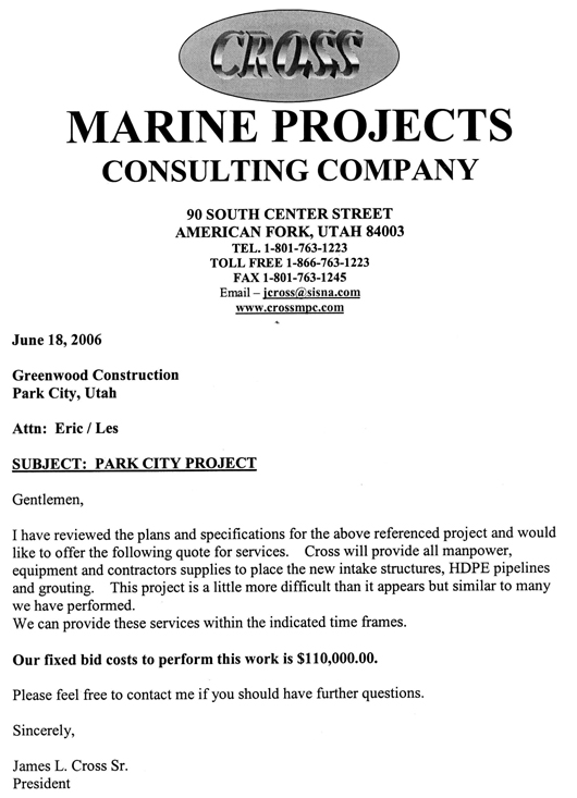
2005 – September 14 – See Sept. 14, 2005 MA Board Minutes, and October 24, 2005 Minutes, and.2005 October 15 to November 10 – Lake Remediation Clean-up Schedule.2006 – June 18 — James L. Cross Marine Projects Consulting Company of American Fork, Utah offered a fixed bid of $110,000 to perform lake repair work recommended by Klinefelder engineering firm hired by Mountain Regional Water and Summit County.
– our MA spent over $145,000 to drain and clean the large lake. Hundreds of resident volunteer hours were donated to complete the work..What the MHOA Board budgeted and spent for Lake maintenance and clean-up:
2005: $34,597.17; Charlie Thompson was hired to apply Rotenone to kill the fish, total cost approx. $5,500
2006: $115,658 from a Special Assessment to the MHOA membership of $69,525
2007: $24, 405; Galen “Buck” Buchenroth of Jackson Hole, Wyoming was hired at $8,000 to assist with catching trout and overseeing the installation of the aerators.
2007-2008: Proposed $90,000. for the Small Lake.
2005-7 – Master Association spent $145,000 to repair lake gates and dams, to eradicate goldfish, and to improve water quality, in the lower pond/large Silver Willow Lake. This expenditure was not voted upon nor approved during a General Membership meeting of the approximate 504 owners as specified by the Bylaws. The Master Association’s primary function is to care for common areas. It is a concern that the newly transferred lakes were in such great need of repairs and clean-up, the Klinefelder Lake Report had provided a list of items that needed to be repaired. A further concern that the MA Board might not have followed the MA Bylaws and probably did not request input and a vote from the General Membership for the assessments requested by the Board of Trustees.
A submersed, rooted, perennial herb. In nutrient-rich lakes, Eurasian Water milfoil forms thick stands of tangled stems and vegetative surface mats. It produces many whorled, finely divided leaves upon nearing the surface. The plant can interfere with recreational activities such as boating, fishing and swimming and can often crowd out important native plants. As with most invasive species, prevention is the best means of containment. Once Eurasian water milfoil invades a body of water it is almost impossible to eradicate it. Herbicides and mechanical harvesting are often used to control infestations of water milfoil.
Another lake plant is Coon’s Tail – Ceratophyllum Demersum.
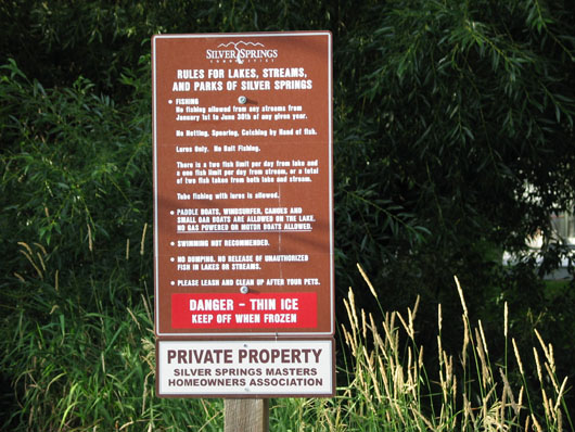
Added PRIVATE PROPERTY verbiage to bottom of lake signs – 2009
SILVER WILLOW LAKE aka Lower Pond
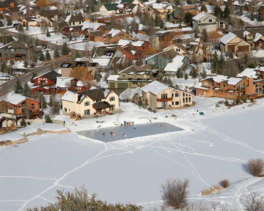
Silver Willow Lake – with Mooney’s “Ice Rink” in 2006, 2007, 2008 – Photo courtesy of Rob Follett
2008 – Master Association plans to spend around $90,000 to clean up the private upper pond/Smaller Silver Springs Lake to which only22 homeowners have use or access. This expenditure was not voted upon nor approved during a General Membership meeting of the approximate 504 owners as specified by the recorded MA Draft Bylaws.
There are approximately 504 General Members in the Master Homeowners Association who all pay an assessment for the Lakes though the Silver Willow Lake front access is now limited to ten homes from Silver Springs Single Family HOA, seven homes from Park Place and eleven homes from NorthShore, a total of 28 homes. The General Membership of the remaining 476 Living Units has access along 443′ via the central Park .
It is believed that the Silver Willow Pond has been granted easement use “for the private and exclusive use” of its lake view owners, 22 or so, depending on how you define lake view frontage. (See map below.) If Silver Willow Pond is private property should the General Membership be asked to pay for its maintenance and insurance?
Silver Springs SFHOA President Michael Winer, and several other SSMA members, are asking the question: If the lake view lot owners have taken the Enjoyment Easement from the General MA membership then shouldn’t they pay a much higher proportion (ten times = 29+ 25 out of 504 units) of the lake repair, maintenance and liability insurance? These expenses can be allocated by taking the actual linear footage of each lot along the lake perimeter and using it as a percentage of the whole perimeter then applying it to the cost of all lake expenses. Additionally access parcels, such as Parcel K, could be assessed by square footage. The individual assessments would be from the Master Association then passed through on individual HOA invoices to members by the individual HOAs, thus eliminating problems with individual subdivision HOA Bylaws.
The market value of the lake view owners lots is twice that of the non-lake view owners. For instance, the home at PP Lot 35 is not on the lake, is listed at $799,000. The home at PP Lot 40 is on the lake listed for $1,595,900.
Alternatively, and the preferred solution, would be to return the Enjoyment Easements to the General Membership, and the Lake costs could continue to be assessed equally to the 504 General Members. Or the lakes could be deeded to the lake view owners and the SSMA would contribute a use fee commensurate with actual General Member use.
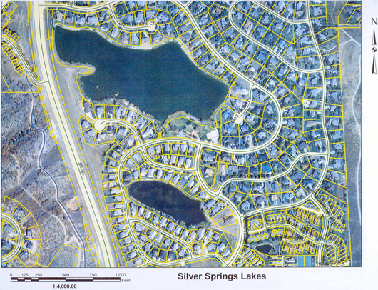
Silver Willow Lake, Silver Willow Pond, Silver Meadow Minnow Pond
Silver Springs Water Company has an artesian well on the west side of the Lower Pond at the peninsula pump house location. Silver Springs Developers have a 25 year lease on water shares from Weber Basin, at a lease rate of $5,000 per year for 190 water shares per Barry Golding Utah Water Division.
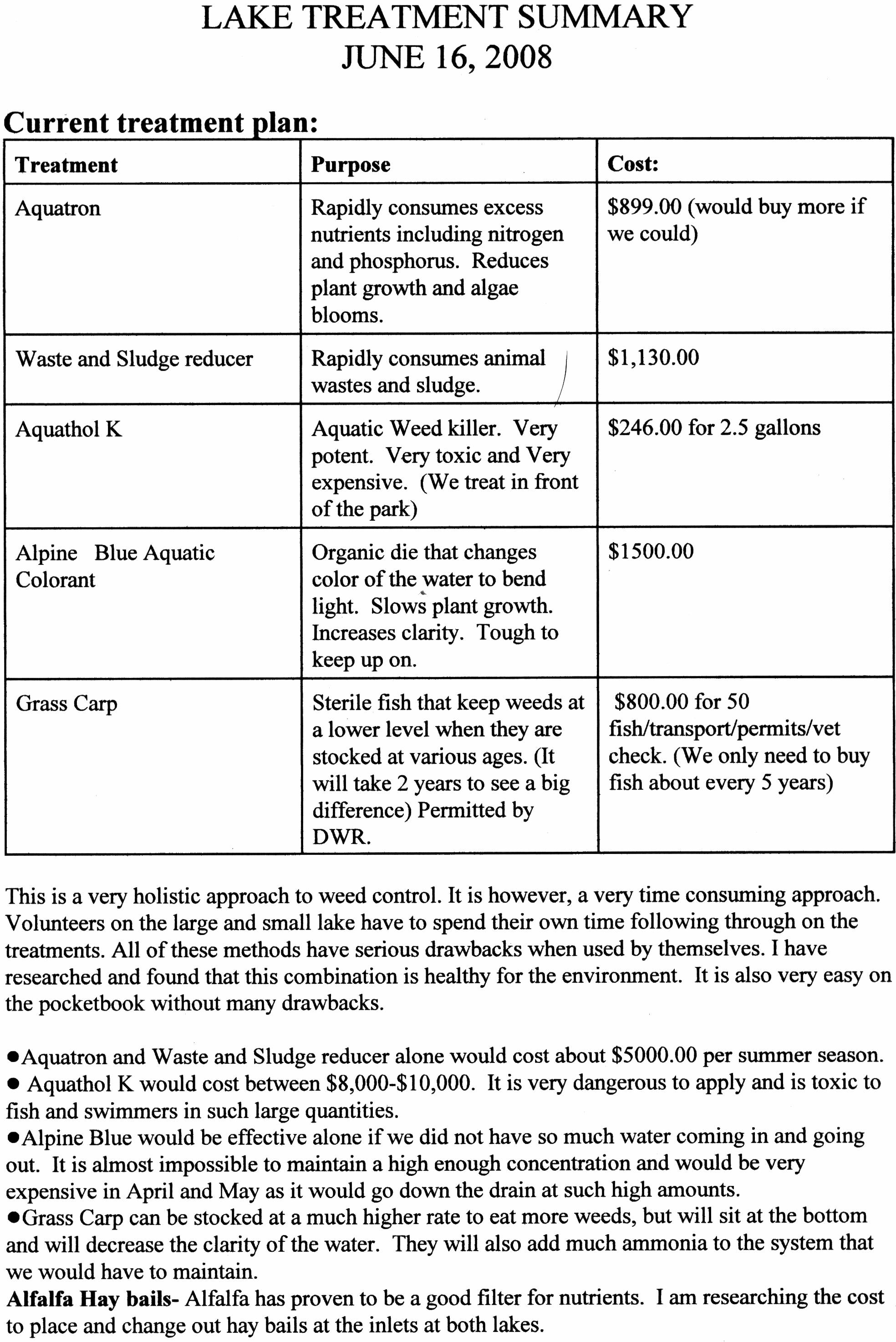
2008 Lake Treatment Summary – By Gaylynn Mooney
The Lake requires several different chemicals to be added once or several times a year in order to maintain a degree of clarity, decrease the foul smell each spring, keep the weeds from growing, etc. The budgeted amount varies from $4,000 to $7,000 for chemicals each year. Gaylynn said she measured the Silver Willow Lake and it is 16 acres. If it is recorded on the survey as 20.84 acres where are the other four acres? Are they the easement and dam areas?
Pond Conservation is the national charity dedicated to creating and protecting ponds and the wildlife they support.
2008 – July 18 Conatser Case – Utah Judicial Law passed regarding access of waterways, diversions, rivers, streams, creeks, lakes (natural or impounded=man-made), etc. Allows the public lawful ingress and egress of all waterways. Water is a public resource in the State of Utah, therefore the public access is granted but must be via public easements only. Public allowed to float, and now touch the waterway bottoms. Canatser Case.
WINTER IN SILVER SPRINGS
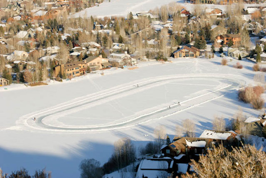
Center of Silver Willow Lake January 2009- with a one-quarter mile “Ice skating oval”
– Photo courtesy of Rob Follett
The U.S. Speed Skating Association created the oval to train on it for an outdoor speed skating tournament. It is uncertain whether they received permission from the SSMA or a lake view property owner. Tracks lead to Mooney’s and Loughlin’s.
2009 – September 15 — Unposted SSMA Meeting ….. Items Discussed:
—the lakes survey completed just prior to July 25, 2009 [the 4th survey – 1978, 1984, 1989, 2009],
—the condition of the new dams built in 2005 [warranted by Cross Marine for 20 years at cost of around $143,000 to SSMA Members],
—the State Water Engineers mandate to remove all trees [particularly aspen, willow, and cottonwood] from the perimeter of the lakes from the rip rap water line inland 25?. This mandate is understandable on or a measured distance from the dams themselves, it makes no sense, environmentally or aesthetically, to remove trees from the perimeter of the Silver Willow Lake [lower lake, large lake, 20.84 acres], or from the perimeter of the Silver Willow Pond [upper lake, small lake, 5.24 acres].
2009 Lake/Waterways Chair Jim Harsch – “The survey of Master Association owned property around the two community lakes is now complete. As soon as the survey drawings can be verified against the numbered stakes in the ground which identify the property boundaries, stakes which are not needed for reference to potential property issues will be removed. Where a clear definition of the property lines is still needed, either the stakes will remain or will be replaced by a sprinkler flag until any issues are resolved. Due to the complexity and variety of property rights and state dam inspection criteria, the owner of each lot with a potential property issue will be addressed individually rather than as a group.”
The following has come to our attention with a request to share it with our neighbors:
To quote: “Jim Harsch, Little Lakefront owner, lives in the annexed Little Lake subdivision of six homes along Silver Springs Drive. He currently is the chairperson of the Silver Springs Lakes Committee whose members include Richard Krebs, Brian Robinson, Harry Fuller, Les Carriel, and Eric Fraleigh (NS). All six of these men are lake front property owners. The first three men are on the SSSFHOA board of seven trustees. Harsch’s election created a majority of four lake front owner trustees of the seven trustees. Four trustees representing the dozen lake front SSSF owners, three trustees representing 177 non-lake front SSSFHOA owners.”
2009 – September – Lakes Emergency Action Plan was filed with the
State Water Engineer’s Office. Everett Taylor, Dam Safety at (801)538-7372.Emergency Action Plan Template for Silver Springs No. 1 (Silver Willow Lake)Emergency Action Plan Template for Silver Springs No. 2 (Silver Willow Pond) OR http://www.waterrights.utah.gov/cgi-bin/docview.exe?Folder
DAMEAPLN00560&Title=EmergencyUT000560 Correspondence with UDWR since May 1996
http://www.waterrights.utah.gov/cgi-bin/docview.exe?
Folder=DAMCORRS00560&
Title=Correspondence&Startup=0.9509428494612
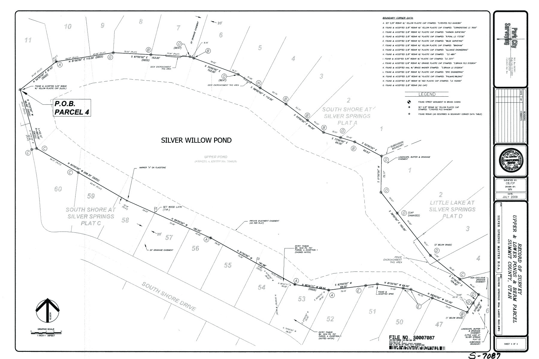
2009 – Sept 8 – Fourth Survey of Lakes – by Bill Noland
As part of the continuing process of conducting due diligence on Master Association property, the land surrounding the upper and lower lakes was recently surveyed. The results of that survey are now on file and recorded with Summit County. Most of the survey stakes have been removed, with just a sprinkler flag or fluorescent ribbon tied to the cap-and-rebar marker left to identify the locations defining Master Association property for future reference.The survey revealed some unresolved issues regarding encroachment across property lines, private easement definition, and encroachment on the profile of the earthen dams impounding the two lakes. Due to the complexity and variable nature of these issues from lot to lot bordering the lakes, and in some cases off the lakes, the Master Association will contact and resolve any issues on a one-on-one, case-by-case basis with individual lot owners. There will soon begin an information process by which the Association membership will be brought up to date of the history of the lake issues at hand, and the relationship of the lake shore property around the two lakes owned by the Association since 2004, to that of the lake view lots which border the Master Association owned property.
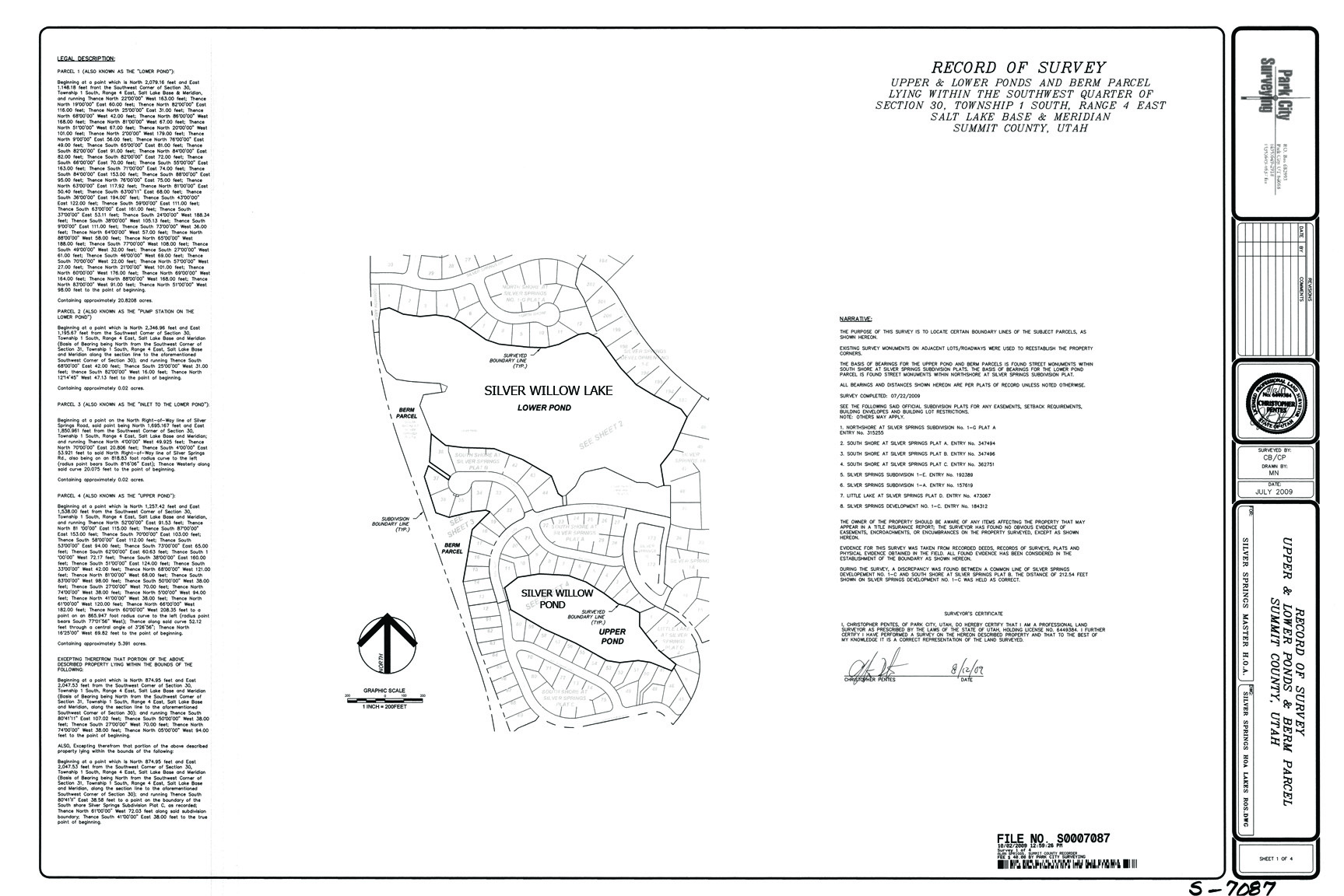
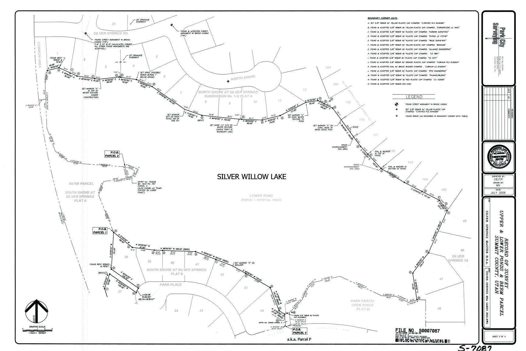
2009 October 2 Survey Map; includes encroachments; does not include easements
2009 October 2 Small Pond-Lake Survey showing Private Easement. Click to enlarge.
https://www.silverspringscommunity.com/wp-content/uploads/lakes-plats-survey-7087-ros.pdf
2009 – Wednesday October 14 – SSMA held an unposted meeting at Parley’s Park Elementary School, 6:30 PM regarding the lake issues and the removal of trees on the dams as mandated by the State Engineer.
2009 – Late October – the SSMA acting President met with SBSRD admin. During this meeting the Silver Willow Lake was offered for sale to the County Recreation District. The offer for the lake was rejected but they would consider the 20 acres under the water for a County maintained Park similar to the management being done for Willow Creek Park.
2009 – November 17 – Quail Meadows II and Ptarmigan have removed their subdivisions from further participation with the SSMA, in part due to the issues surrounding the lakes. The Springs subdivision no longer participates in the SSMA, leaving only ten subdivisions on the board or to assess dues for lake expenses.
2010 – February 9 -SSMA Annual Meeting. A Special Capital Improvement Assessment for $182 was added to the $175 annual dues for the Master Association, $357 multiplied by 504 residential units = $180,00. The SSMA board has claimed they have the Mountain Regional $32,000 check in savings and a $80,000 CD. Proposed cost for the Little Lake repairs on the 2010 Budget is $135,000. How is all this money reconciled? The SSMA board received heated dissent during this meeting regarding their proposed additional assessment for work on the private little lake. The SSMA board did not ask for a vote from the Silver Springs Community property owners as required by the Bylaws and HOAs CCRs. After much dissent and debate for the next six months, the SSMA board found that their assessment for the little lake work was twice the actual cost. There has been discussion to refund a portion of the $182 assessment to the property owners.
Update on Condition of the Silver Springs Lakes by Gaylynn Mooney
- Natural Problems:
– Man-made in 1980. Not naturally occurring bodies of water.
– Original intent was retention ponds for storm water storage and eventual subdivision irrigation system.
– Have become gathering pools for sludge, silt, road salt, and phosphorous and sulfur run-off.
-The cycle of plant growth and death (decomposition) create an excessive build up of plant growth nutrients, phosphorous and nitrogen.
-This nutrient rich environment becomes a haven for coon grass, milfoil, and various aquatic vegetation. As algae grows, blooms, and expires the huge algae blooms fed by the abundance of decomposing materials in the water, all this plant life provides an abundance of oxygen.
-The abundance of oxygen produced by these plants works to decrease the life and existence of beneficial trout we were used to seeing in our lakes in the 1980s and 1990s.
– As the trout and other beneficial fish population decreased there were no fish to eat the leeches, so the leech population exploded.
See How to Trap Leeches. You can use coffee cans or plastic buckets with holes punched all around the sides. Trout are nearly never spotted in our waterways during the last decade.
- Mechanical Solutions:
– The most effective and “free” method of ridding the lakes of the cycle of plant growth and decomposition is to rake or pull the plants out of the lake. Removing the plants decreases oxygen production and the nutrients that result from plant cycles.
– Aerators are run on the Little Lake via electricity paid for by the MA. The Big Lake electricity is paid for by Mountain Regional.
-Last summer the east big lake drain structure was tampered with and lowered by 1″, during the winter ice built up and a leak was noted along the NorthShore outlet stream in January 2010. Cross Marine was called by a lake view owner to make the repair adjustment. Cross Marine provided divers to caulk the aerator leak and restore it to vertical position at a cost of $8,000 to the Members of the MA.
- Chemical Solutions:
– Chemical weed control is quick and relatively easy, however the nutrients are not removed, decomposition still occurs, and the trout die.
– Aquathol, Aquatron, Aqua Blue, and Alpine Blue are some of the chemicals being added to the lakes.
– Aqua Blue is a dye that decreases the amount of sunlight that reaches the bottom of the lakes where plant growth occurs. The most effective time to apply this is in the spring but that is the time of year when run-through is the fastest and greatest from the inlet streams.
– Chemicals require many applications to be effective, “some are ridiculously expensive.”
– Timing of applications can be tricky, if not in conjunction with optimum conditions then the effect can be minimal.
– Application is time consuming and hard work for the ones who are charged with the responsibility.
– Annual MA budget for chemicals is around $8,000.
- Biological Solutions:
– Aquathol is an aquatic herbicide being used in floating water-soluble packets of bacteria and enzymes for plant control.
– Last summer 12″ grass carp were introduced into the large lake. A number of them lived a few months before they floated, belly up, to the surface. The grass carp are considered more as preventors of plant growth than correctors. They grow to be 4′-6′ in length, growth is dependent on the size of their environment.
– Grass carp are different than the goldfish (also in the carp family) that populated the lakes before 2004 because grass carp have an extra set of DNA so cannot reproduce, where goldfish ate the trout eggs and also lay their own eggs every couple weeks, hatching in 48 to 72 hours.
- Lake Enhancements:
– Adding rocks or gravel to the perimeter of the lakes or the bottom would be very costly. Environmentally and ecologically, wild flowers and grasses would work better.It is unsettling to make plans to enhance the lakes as the 2004 Lakes Conveyance Agreement provides that Mountain Regional retains the option to again use the lakes for water storage and fire suppression, and has the right to renegotiate the Agreement in the future.
2010 April – Silver Springs Homeowner Verda Lewis recalls riding her bicycle in the area known as SouthShore around 1988 or so and remembers there was no Little Lake, at least not as it is today. The lake bed had not yet been filled in with water.
2010 April – Another Silver Springs Homeowner Dan Morgan recalls when he was around 13 years old that he and his friend (who lived in Meadow Wild – Jared Allen) had built a fort, with plywood and scrap lumber, in the meadow where the Little Lake later was to appear, against an embankment which now is filled in with water.
2010 April – Another Silver Springs Homeowner Carolyn Fouse recalls when bulldozers pushed all the top soil from the Silver Springs phase that eventually became SouthShore, into a huge pile along the west edge of Silver Springs Drive. This top soil was sold off during the next 2 or 3 years by the developers and the land was subdivided into the six lots known as the “Little Lake homes at Silver Springs”. You may remember that the local children would sled down these snow covered topsoil piles in the winter.
2010 – April 22 – Lake view owners form a MA committee to make Rules and Regulation for Lakes and Common Area use. Draft Rules and Committee.
2010- December 10 – Lakes Enjoyment Easement – At this SSMA meeting Bill Noland announced that the attorney’s he hired to research the Silver Springs documents have found that the 1989 Enjoyment Easement Agreement around the Little Lake runs with the land and is a valid Agreement from the developer to the purchasers of the lake front properties and their successors for the use and access of the perimeter of the lake. The six Little Lake homes located on the east border of the Little Lake along Silver Springs Drive, and annexed in 1997 as part of the SSSF subdivision, are not included in this Agreement as these six lots were not part of the (Mike Barnes) developer’s property. View at: https://www.silverspringscommunity.com/our-community/silver-springs-sf/little-lake-at-silver-springs/
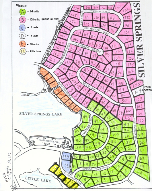
The same situation exists for the Large Lake in that the seven homes along the east border of the lake are part of Silver Springs Single Family since the beginning in 1980 and were never part of the developer’s (Barnes’) Enjoyment Easement Agreement. Therefore the 1989 Agreement does not guarantee use and access to lake front properties SLS-E Lots 192-199 https://www.silverspringscommunity.com/wp-content/uploads/phases-a-e-color530pxxx.jpg
Does this mean there is NOT access to all the ponds/lakes and easements to all SSMA Members along these Private Enjoyment Easements? If the Easements are Private and Exclusive why does the SSMA bill ALL the SSMA members for maintenance, repair, insurance, taxes, and management of properties owned by SouthShore and/or private owners? The MA board and Noland would not answer Lucy Archer’s question. SSSF lake view lot owners and board members (Harsch -Lot LLSS-1, Krebs -Lot LLSS-4, Fuller -Lot 193, Hedges -Lot 194, Carriel -Lot 195 , Robinson -Lot 196) not located within the 1989 Private Exclusive Easement petitioned the board in Fall 2010 to allow them to purchase the easements from the Master Association. The request was tabled until further information was confirmed. (Later it was learned the board did allow these lakefront lot owners to gain title to the easement parcels between their home lots and the lake/ponds.)
2010 – Silver Willow Pond – 5.24 acres with surrounding privacy vegetation
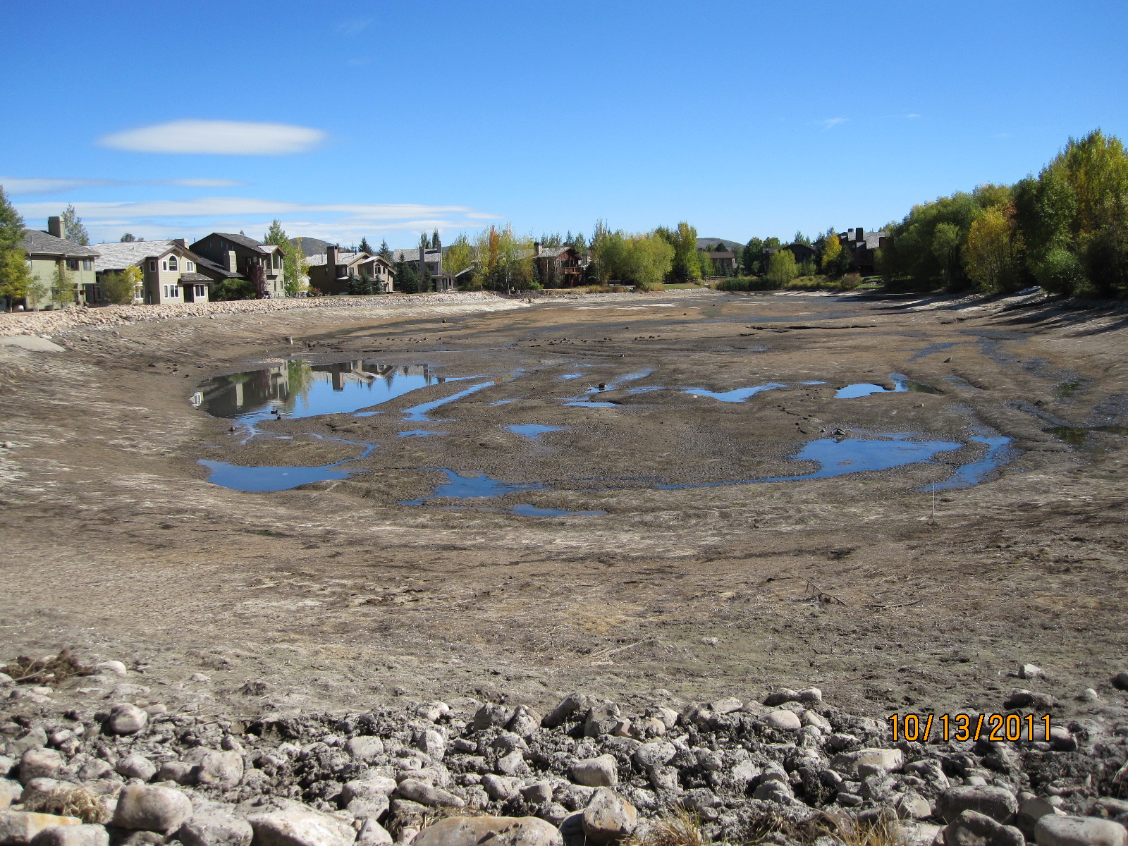
October 2011 – THE UPPER LITTLE POND WAS DRAINED – REPAIRS IN PROGRESS
Click here for Upper Small Pond extended information
Small Pond refilled
End of 2011 Lakes Report
- Little Lake work is complete and well under budget. The Utah Dam Safety department has issued an acceptance letter to the Master Association for the Little Lake repairs.
- There was some discussion regarding the MA budget surplus and the decision was made by the MA Board to keep the surplus for future projects – namely possible additional big lake dam profile work. The MA collects $88,200 each year, where does that money go?
- 750 trout were released into the big lake and there will be additional trout released into the little lake when it is filled next spring 2012.
- There was discussion about rehabilitating or improving the area near the peninsula pump house to the west of the big lake. The pumphouse and well are owned by Mountain Regional Water Company/Summit County along with a 100′ perimeter around the pump house. Parcel “R” and Parcel “J” belong to the the Master Association and, like the lakes, have not been utilized by all the neighborhoods.
-

SouthShore lakefront owners enjoy storing their boats on their Private Exclusive Easement –
Only lot owners contiguous to the water have access and use of the Silver Willow Pond and perimeter.
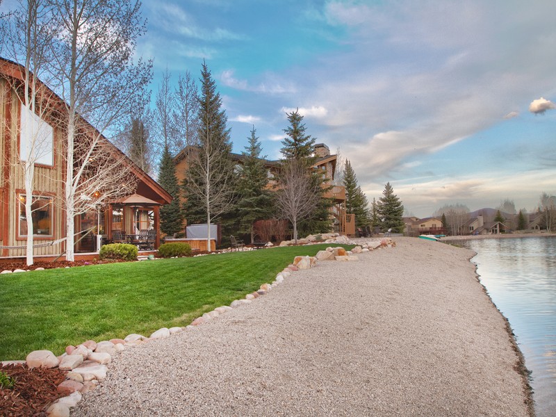
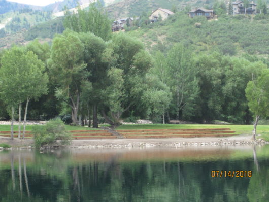
Silver Willow Large Pond – beach, trail, dam – all in one.
ENJOYMENT EASEMENT INTENDED IN 1982 FOR USE BY
ALL COMMUNITY OWNERS.
In 1984 this easement was reserved to the “premium lot” owners. In 1989 the new developers of NS Lots 1-11 and of 22 Southshore lots provided a “Private Enjoyment Easement Agreement” making the contiguous trail easements “Private and Exclusive.”
All 500+ Silver Springs residents pay for the easements and lakes. In 2010 the Master Association was requested by the MA Property Owners to tier the MA dues to reflect a differentiation between the private and the public areas [https://www.silverspringscommunity.com/master-association/2010-survey-ballot-results/]. The MA has not responded to the Community Property Owners request.
2014-September – The board voted to eliminate one of the two back flow preventers on the little lake. The little lake valve will be combined with the South Shore Berm – SOS-A-. Mountain Regional will charge the MA$250 plus eight times the base rate of $56.00 for a total of $698 to remove the one valve, thus also saving the monthly fee. They also require that the meter be installed to code in a larger man hole. (Cost $$$). Now backflow preventers have been installed on all the irrigation lines. Both lakes had new compressors installed and were stocked with sterile rainbow trout.
2014- November- Summit County Commission has approved increased setbacks of 150 feet from bodies of water. Most SSMA homes do not meet these requirements. In Park City water set backs are fifteen feet.
2017- November – Lucy Archer delivered a proposal to the Master Association offering to collaborate with them on the production of a map of our Silver Springs Community showing the various “amenities” and which ones were available to ALL of the Community Homeowners and which ones were “private” yet were funded from ALL the Members dues. The map below is what was produced. By clicking on each colored area or line you will be provided with limited information on the parcel.
Link to Interactive MA map will be added when it has been properly edited.
2018 – May – Silver Springs Master Association funded twelve new aerators, diffusers, etc. using your collected annual dues.

The Silver Springs Master Association, with the help of some of the lake-front homeowners (Dittmer, Carriel, Mooney, Rand Howard, others?), has installed a $60,000+ new water aeration system with 12 aerators on the large pond (20.84 acres). Also the 6 aerators installed into the little 5.24 acre pond, and the pumps, weighted hose, and diffusers installed into this small pond were relocated from the old aerator system of the large pond.
The water in these ponds has been progressively getting more stagnant and murky. The sterile trout it was stocked with have been dying at an alarming rate. It was reported in November 2017 that the blue dye used here, has been doubled making little effect.
If the 300 to 400 ACRE FEET of ground water that is being discharged out of our neighborhood each year by the efforts of the UNSANCTIONED underdrain committee was instead channeled into these ponds there may be a longer lasting life expectancy than the four or five years stated in the M.A. Minutes. This aeration system is an effort to revitalize the remaining stagnant water.
The photo above shows Park Place subdivision at the top right (south end). The 1.2 acre Master Association Park is on the top left lake shore (south).
North Shore Court at the photo bottom (north end) of the pond. Four, almost five, Silver Springs SF houses are shown on the bottom left side of the pond.
The peninsula on the right (west) is property of Mountain Regional Water. The well located there is no longer active, at 500 feet depth it no longer has enough water to pump a supply to our community. There are a number of artesian springs under this pond that used to supply fresh water to the pond. However, since the groundwater table has been progressively lowered by climatic conditions, and the unsanctioned rotorooting of the underdrains, during the last decade, it is now believed this pond is predominantly dependent on surface water from creeks and channels running through our community.
NOTE—Webmaster invites contributions of information, dates, pictures, comments, send to [email protected]