1987 – Parcels B/8, H, I, K
Parcel B at bottom center of this Exhibit.
October 15, 1987
AMERICAN SAVINGS—Legal Department
To: Mr. Dale Boschetto, President
Silver Springs Homeowners Association
1461 West Willow Loop
Park City, Utah 84060
RE: Silver Springs Development.
Intended Disposition of Certain Properties on the Silver Springs Lower Pond Water Front.
Dear Mr. Boschetto:
In 1986 American acquired by foreclosure certain property within the Silver Springs Development.Much of the property is unplatted, some is divided into building lots and a few parcels have been given special designated uses. Included in this final category are parcels “K”, “I”, “H”, and “8” as found on the [July 1985 J.J. Johnson] attached map.Another piece of property which has been given a special use designation is a strip of land fifteen feet wide immediately outside the riprap surrounding the lakes. This fifteen foot strip is owned by the Silver Springs Water Company.
The use of these parcels has been a source of conflict among some Silver Springs property owners and certain entities with interests in the Development. Many of these have approached American with suggestions as to the final disposition of the parcels. American Savings has looked closely at each suggestion and at the original intended uses to the extent we have been able to find them. We now set forth the following as our intended disposition of the parcels.
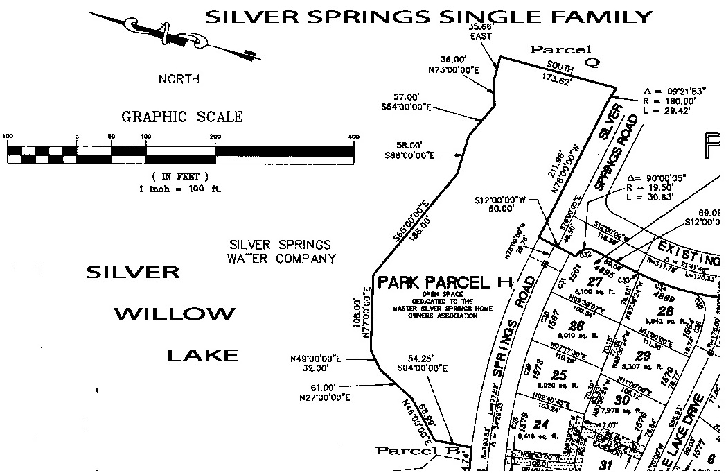
1.PARCEL H. Parcel H is approximately two acres in size and has had several suggested uses. It is the area of the Water Company to the lake front. The access and [irrigation system] pumping area is at the east end of the parcel and contains the lake’s inlet stream. The Water Company now holds title to the stream bed.
Parcel H has also been unofficially designated as the site for a future park, lake access and boat dock for the homeowners of Silver Springs. Virtually everyone involved in the Development is in agreement that this has always been its intended use. Parcel H is large enough, however, to give the Water Company ample room for its [irrigation system] pumping equipment and lake access, to give the Homeowners Association its park and still have room at the west end for other development [Park Place].
American intends, therefore, to convey as much of the easterly portion of the parcel to the Water Company as it will need to maintain its pumping equipment and to have adequate access to the lake front. American further intends to convey approximately one-half of the remainder of Parcel H to the Silver Springs Homeowners Association for use as a park, dock, or other such use as it sees fit. Title to the remainder of Parcel H will remain in American.
2.PARCEL I. It is unclear whether Parcel I ever had a particular use designation. It is probable that it is merely a discrepancy between the platted lots and the actual water line.No one but the adjacent lot owners seem to be interested in Parcel I. [Did American canvas the other lot owners? No.] It has a sewer line running underground through it from the east end of Parcel H to Parcel K and is subject to a sewer line easement. [HOA held this area since 1983 when the lake was dredged as a common area beach accessed by Parcel K]
American intends to offer to sell this parcel to the owners of the lots which it abuts.It would be sold subject to the sewer easement and at a price or prices to be agreed to by American and the homeowners involved.
3.PARCEL K. Parcel K is a 25 foot wide strip of land [an easement appurtenant by necessity] connecting Silver Springs Road to the lake front. Originally it was intended that this strip hold the water pumping equipment for the irrigation system which the lake would service. The equipment site was changed to Parcel H and Parcel K has been left as an accessway to the lake from Silver Springs Road. [In American Savings letter of December 6, 1988 Ryan L. Richards modifies these “intended uses”.]
Some of the homeowners have suggested that this be used for foot traffic from Silver Springs Road to the lake front. However, because Parcel H will be designated for homeowner access to the lake, it is intended that American will sell Parcel “K” to Bill Ligety, who owns the lot adjacent to the parcel and has expressed interest in purchasing the parcel. [ HOA also offered to buy this parcel even though it was already considered an HOA common area parcel. American neither solicited nor gained general membership approval.]
4.PARCEL 8 or B. American has been unable to ascertain the original intended use of Parcel 8. It is intended therefore that Parcel 8 be added to the parcels adjacent to its western border. [Parcel 8 was part of the “Enjoyment Easement” visible on American Savings map titled “For General Location of Common Park, Recreational & Open Area Proposed for Master Association” It is located between Park Parcel H and Park Place Lot 44. It is contiguous with Parcel P, a lake inlet stream parcel.]
5.THE FIFTEEN FOOT STRIP – [“Enjoyment Easement”] The 15+ foot strip surrounding the lake just outside the riprap is owned by the Silver Springs Water Company and is intended to be used for access by the Water Company to the lake front. Whether the strip will also be permitted to be used as access by homeowners generally will be determined by the Water Company and the owners of the lots on the lake front. [Lynn Stevens, manager of the Silver Springs Water Company, the entity that holds title to the common area Parcels H, I, K, the “Enjoyment Easement”, and others, has promised the HOA on numerous occasions that the water company fully intended to convey said parcels to the HOA. “…..all property owners in Silver Springs have the water company’s permission to walk on the 15’+ easement around the periphery of the lakes and along the banks of the streams….”]
In addition to such purchase price amounts as will be negotiated by American and the parties receiving the conveyances described above, American will require the execution by those parties of agreements to hold American harmless from further disputes in connection with all conveyances made prior to and as a result of this letter and with all users designated herein or by present and future owners of these parcels.
American hereby invites all interested parties to comment on the intended actions set forth in this letter.All comments should be received no later than November 15, 1987, and should be addressed to American Savings and Loan Association, 77 West 200 South, Salt Lake City, Utah 84101, Attention:Ryan Richards, Legal Department.
Very Truly Yours,
AMERICAN SAVINGS AND LOAN ASSOCIATION
Ryan L. Richards, Esquire
Staff Attorney
1988 – August 8 – Letter from American Savings Attorney Ryan Richards regarding Silver Springs Parcels.
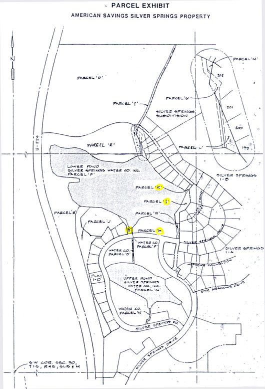
July 1985 Silver Springs Parcel Exhibit for American Savings
– drawn by J.J. Johnson Engineering Company
APPEAL PETITION
To: Jerry Smith, ZoningAdministrator November, 1988
SummitCounty Planning Commission
From: Scott C. Welling
Attorney for Appellant
RE: Appeal from Planning Commission Action
Appellant: Silver Springs Homeowners Association
Snyderville, P.O. Box 3323, Park City, Utah84060
Notice is hereby given that the Silver Springs Homeowners Association, appellant above named, hereby notifies and petitions the Summit County Board of Adjustments for review of that certain (herein after “Commission”) on September 13, 1988, as is hereinafter described.
Appeal is made pursuant to Sections 4.2(2) and 4.6 of the Summit County Development Code (hereinafter “Code”). The appellant claims standing as a person aggrieved y the decision of the Commission made in the course of the administration or enforcement of the provisions of the Code.
STATEMENT OF FACTS
On September 13, 1988, at its regularly scheduled meeting, the Commission, by a majority of its members, gave an interpretation that the previous master plan and project approvals for the Silver Springs Subdivision would be to prevent the sale of certain small, undeveloped parcels near the major lake within the subdivision to several individual homeowners whose properties are adjacent. This determination by the Commission was made pursuant to the request of American Savings and Loan Association, apparent owner of said parcels, and the successor in interest to the developers of the3 Silver Springs Subdivision.
Discussion of the issue included the conflicting views of several subdivision homeowners and a representative of the homeowners association to the effect that the subject parcels, as well as other undeveloped or unplatted areas within the subdivision were intended to be and should be reserved as common or park areas for the benefit of all owners within the project.No motions was made nor vote taken with regard to the interpretation of the master plan and the determination by a majority of the members of the Commission that the subject parcels were not intended for use as common areas, and thus American Savings could not be prevented by the Commission or the master plan from selling the subject parcels to adjacent property owners.A vote was taken, however, concerning the use of a larger parcel (parcel “h”),With The Commission determining that such is a subdivision common area.(See minutes of Planning Commission meetings held August 23, 1988 and September 13, 1988.)
BASIS FOR APPEAL
Appellant contends that the Commission erred in its interpretation and determination of the status of the subject parcels in the following particulars:
The Commission’s determination was made contrary to the master plan, and the conditions and representations of the original developer that were a prerequisite to the approval to the approval thereof.
- The Commission’s determination was made in absence of the record of previous proceedings, submissions, and conditions to approval of the master plan and subdivision plats.
- The Commission’s determination is contrary to the Declaration of Covenants, Conditions, and Restrictions for the subdivision and the amendments thereto.
- The Commission’s determination constitutes an amendment to the master plan for the subdivision, but without compliance with the provisions of Section 2.8 of the Code concerning submission of maps, master plan designations and ownership status of the property.
- The Commission’s determination is contrary to the provisions of Section 3.7 of the Code, to the extent that the subdivision constitutes a pre-existing and non-conforming land use, and therefore violates the provisions of Section 13.6 of the Code requiring that all open space within a subdivision be platted.
CONCLUSION
As a consequence of the Commission’s determinations, appellant will suffer the immediate and irreparable loss of use and diminuation in value of lands within the subdivision, and will suffer the consequences of an impermissible revision of the master plan for the subdivision.Such action may have the effect of nullifying pre-existing conditions of plan approval and establishing a precedent for future interpretation or modification of the plan without benefit of the due process procedures mandated by law and the Code.For these reasons, all proceedings, acts or omissions in furtherance of the Commission’s decision which pertains to Parcels I and K of the subdivision should be stayed, and the Board of Adjustments should schedule a hearing and make a determination hereon in accordance with the provisions of Section 4.8 of the Code.
Respectfully submitted this _________day of November, 1988
Scott C. Welling
Attorney for Appellant, Silver Springs Homeowners Association
AMERICAN SAVINGS—Legal Department
December 6, 1988
Scott C. Welling, Esq.
312 Main Street
P.O. Box 712
Park City, Utah84060
RE: Silver Springs Development
Dear Mr. Welling:
I thank you for your letter of October 28, 1988 regarding the disposition of certain parcels of land in the Silver Springs Development, Snyderville, Utah.Rather than address each of your concerns individually, I will recount the steps we have taken with regard to these parcels and why we have been justified in taking them.I am hopeful that American Savings and the Homeowners can come to a common understanding of the status of the parcels and the rights of all interested parties.
Development of the Silver Springs community began formally during 1978 with the submission of the proposed master plan to the Summit County Planning Commission by the then developer, Vern Hardman and Paul Anderson, Phase I of the master plan was approved in a Planning Commission meeting on May 30, 1978.
American Savings became involved in the project in July of 1980 when it extended a loan to the developers. In 1983 two new developers, InSource, Inc. and Hazelwood, Inc., assumed the loan and development obligations. Though lots were sold and homes were built in the subdivided portions of the development, continued development ceased when InSource and Hazelwood defaulted on their loan obligations and filed bankruptcy. In November of 1986, with permission of the Bankruptcy Court, American foreclosed its loans and acquired title to the unsold lots and much of the undeveloped areas. We have continued to sell lots and are presently looking for a successor developer to purchase the undeveloped areas and finish the project.
The heart of the present dispute is a difference of opinion among a small number of homeowners regarding the use of Silver Willow Lake, its inlet and outlet waterways and three parcels of undeveloped lake front land.These are Parcels H, I, and K as shown on the map attached to this letter as Exhibit “A”. American’s involvement in the dispute began in April 1987 when I received telephone calls from Mr. Bill Ligety, and Mr. Dale Boschetto. Mr. Ligety, who owns Lot #193 adjacent to Parcel “K”, offered to purchase Parcel “K” from American, explaining that it was his understanding that the Parcel had originally been intended to be used as a site for Silver Springs Water Company pumping equipment but the Water Company had decided to locate the equipment elsewhere. Mr. Boschetto had called on behalf of the Homeowners Association explaining that Parcel “H” had been designated as the site for a Homeowners’ Park and asked when American could convey the Parcel to the Association.
As a result of these telephone calls and my subsequent inquiries here at American, I was asked to assist in the disposition of these Parcels. Members of the American Savings staff and I gathered all of the relevant documents in our files, inquired of numerous county, state and federal agencies regarding the original intended use of these Parcels, interviewed many Silver Springs residents, Water Company officials, and former developers and devised what we decided was a fair and proper plan for conveying the parcels to the parties to whom the parcels were intended, or in the absence of identifiable intended uses, to the parties with the greatest and most immediate interest.
From our investigations we made discoveries and came to conclusions as follows:
WATERWAYS: Silver Willow Lake, its inlet and outlet streams and the surrounding riprap together with a 15 foot buffer strip outside the riprap are owned by the Silver Springs Water Company. Use of these by the Homeowners and others will be regulated by the Water Company.
PARCEL H: I was able to locate three versions of the master plan which dealt specifically with Parcel H. Because dates were omitted, I was unable to determine which was the most current, and therefore, which stated the current intended use of the Parcel. The one which the Planning Commission believes to be the original depicts Parcel H as subdivided into single family lots. A second shows four single family lots at the west end of the Parcel and the east end dedicated for the use as a park. The third shows the entire Parcel to be used as the location for a number of recreational facilities. Having been told by Mr. Boschetto that the Homeowners wished to put a park on the Parcel, we opted for the second plan.
PARCELS I AND K: We discovered that the original development plan directed a water pumping station be located just offshore of Parcels I and K, Parcels I and K were created to provide the Water Company an accessway to the pumping equipment [for the irrigation system]. I have attached a portion of the original plan as Exhibit “B” showing the original location of the pumping station.The pumping station location was subsequently changed to the east end of Parcel H and the original site was abandoned.
We were unable to find any evidence that either of these parcels was ever designated as common area.We then considered what the most appropriate use of these two parcels would be.The two uses being suggested by homeowners were (1) to designate them as common areas [as stated by the S.S. Developers, Inc.] and (2) to sell them to adjacent property owners [as suggested by Mr. Ligety].
Those living on the lake front face the possibility of public foot traffic along their back yards if the parcels are made common areas.This, we felt, would substantially impact the value of their properties and their expectations of privacy.[The impact would be similar to that of the lots adjoining the parks, tennis courts, trail entrances, school, commercial parcels, etc.]Representations had been made to them when they purchased their lake front lots that the lake front abutting their lots would be for their exclusive use.
[These statements were hearsay and unverified. Representations had been made in the same manner to non-lake front buyers that they would have use of the full circumference of the lake along a 15’ “Enjoyment Easement” and other waterways reserved for all Silver Springs Homeowners. In fact, Mr. Ligety was a proponent and moderator of a Silver Springs Resident I.D. card to be carried by the users of the “Enjoyment Easement” should their right of use be challenged by a lake front lot owner.] [For the record, Cyndi Sharp, Mr. Bill Ligety’s wife, was the developer’s real estate representative for the sale of Silver Springs lots through Capson, Morris, & McComb, while she also is named on an early document as a member of the Silver Springs Homeowners Board in 1983.]
That is not to say that the lake was represented to be for the use by a few, rather, the lake front abutting the private lots was for exclusive use. [That is to say that if the access to the lakes common area parcels were privatized and sold to the abutting landowners then access would be cut off and the lake would, and did, become “for use by a few”]
Those few [500 owners in S.S. Community, 28+24 live on lake front lots] Homeowners who do not live on the lake front but who live closer to Parcel K than to Parcel H or the outlet stream or other accessways to the lake face the inconvenience to walking, driving, or riding a little further to get to the lake if Parcels I and K are not for common use.Some of them purchased their lots under the representations that they could walk across Parcel I and K to get to the lake.
It is unfortunate that conflicting representations were made by the parties selling the lots and I am confident that these conflicting representations were not authorized by the original or successor developers or by American Savings. We weighed the conflicting interests of those living away from the lake and to us the outcome was clear. Interests of property value and of expectations of privacy far outweigh those of convenience. Consequently, we proposed to convey Parcel K and I to adjacent lot owners [Mr. Ligety of Lot 193 received the lake access Parcel K ; and Carl Caughran of Lot 47, Richard Groth of Lot 48, and Robert Petrarca of Lot 49, received the beach front common area Parcel I.]
You refer at the top of the second page of your letter to a December 18, 1976 intention to convey the Parcels to the Homeowners. I have reviewed carefully the correspondence in our files, have spoken with former members of this legal staff and of the then legal representation of the Homeowners and find no offers to convey. [See: June 7, 1989 Silver Springs HOA Meeting Minutes = Lynn Stevens, manager of the Silver Springs Water Company, the entity that holds title to the common area Parcels H, I, K, the “Enjoyment Easement”, and others, has promised to convey said parcels to the HOA. “…..all property owners in Silver Springs have the water company’s permission to walk on the 15′ easement around the periphery of the large lake…”]
On October 15, 1987 I sent letters to the Silver Springs Water Company, the Homeowners Association in care of Dale Boshetto as President, and to the lot owners whose lots abut the subject Parcels which set forth the result of our research and our intended disposition of the Parcels. My letter invited comments regarding our investigation and decisions and I asked that comments be returned within thirty days of my letter. We wanted to give interested individuals opportunity to present evidence that we may have overlooked or had been unable to find that might help us determine the best uses for the Parcels. In response, I received three letters opposing conveyance of Parcel K to Mr. Ligety and eight letters with approximately fifteen signatures [lake front lot owners solicited by Mr. Ligety; members-at-large were mostly unaware that this contest was taking place] supporting our decision. None opposed the conveyance of Parcel I to the adjacent owners.
Sometime after the expiration of the thirty days, I received a phone call from Mr. Boschetto, he requested additional time to respond because he hadn’t had time up to that point. I gave him two additional weeks to respond. Shortly thereafter I received a letter from him offering to purchase Parcel K at a price based upon the conveyances of Parcel I to the adjacent owners. At that time, he appeared not to have any objections to American conveying Parcel I to the private individuals.
After reviewing the letters and conducting some additional research, the decision was made to dispose of the Parcels in the manner set forth in my October 15 letter. In April of this year, I sent a second letter to the same individuals as the first announcing that decision and then I proceeded to prepare and extend offers to Mr. Ligety and to the Homeowner in care of Mr. Boschetto. The response was an escalation of the dispute and threats of lawsuits by the Homeowners to stop the sale to Mr. Ligety. Allegations have been made that inadequate research had been done and that zoning laws would be violated if American were to sell Parcel K [an easement appurtenant by necessity] to Mr. Ligety.
At that point, I made a formal request of the Summit County Planning Commission to opine as to American’s legal rights with regard to the use of the Parcels. Mr. Smith, Director of Planning, responded that the location of much of the documentation of the project was not known, nor, he suspected, if it were found, would it describe in the detail we needed exactly how the Parcels asked about should be used. Thus the Commission was not prepared to issue an opinion as they would attempt to locate current plats and master plans and would discuss the problem in one of their August meetings.
To avoid the incurrence of legal fees and in an attempt to calm the dispute, I revoked the offers to Mr. Ligety and to the Homeowners and indicated that American would wait for the Planning Commission’s investigation results to take further action.
As you know, the Planning Commission made a review of the available documentation, an onsite inspection and took comments at two different regular meetings. Their findings were that American can do what it wishes with Parcels K and I without violating the master plan or the zoning ordinances and that the entire Parcel H was presently approved for a park site and could not be split in half without amending the master plan.
Satisfied that we had made our best efforts to determine which parties were best entitled to use of these parcels, I proceeded to contact the Homeowners and the parties whose lots abut Parcels K and I to extend offers. As you know we changed the offer to the Homeowners to include the entire Parcel H rather than one half. All parties except the Homeowners accepted the offers and all but one have closed and it is expected to close in the near future. [The offer by the Homeowners to purchase the lake access Parcel K was ignored.]
It is my hope that the Homeowners will take Parcel H. It is available to them and they could begin at their pleasure to develop it as they wish. It will be left to a successor developer to designate and convey to the Homeowners the remainder of the four acres of park [2.1 acres] and common area if it determined that obligation exists. American Savings, having taken possession by foreclosure, is not obligated to finish the development. We are simply not in that business. We are, however, seeking to find a purchaser/developer who would be able to finish the project. Our offer of Parcel H to the Homeowners is simply for their accommodation and came at their request. [The Homeowners already held the right to the park Parcel H by virtue of the master plan and the open space requirement of the County.]
I hope this clarifies our prospective. Please call with any questions you may have.
Very truly yours,
AMERICAN SAVINGS & LOAN ASSOCIATION
Ryan L. Richards, Esq.
Corporate Counsel
NOTE: All information in brackets, [ ], was added to the original text for clarification and identification accuracy.
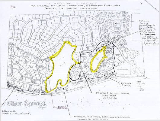
1986 Silver Springs General Location of Common Park, Recreation & Open Areas
– drawn by J.J. Johnson Engineering Company
1983 – HOA member big lake shore access = 4,221.71 linear feet X 15′ wide
1991 – HOA member big lake shore access at community park = 443′ linear feet