Parcel K -Lake Access-LOST
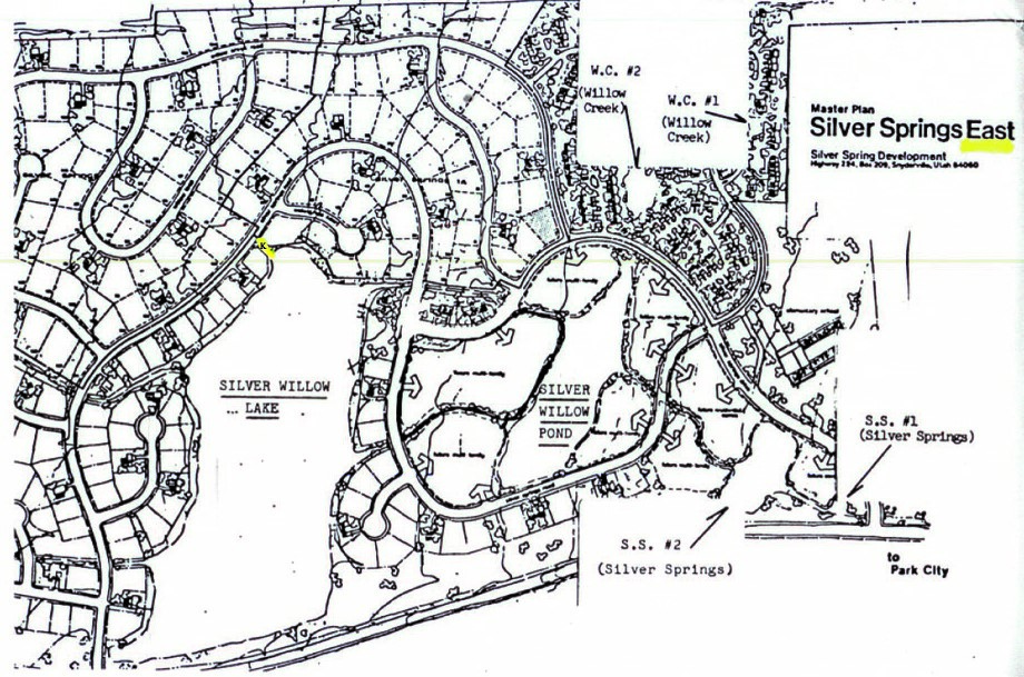
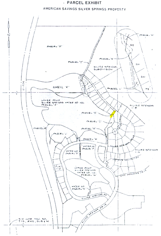
PARCEL K shown on the 1979 Summit County Silver Springs Master Plan
(Click on map to enlarge. Enlarge further by holding down CTR while tapping + key.)
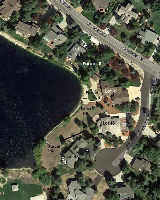
Parcel K : Common area lake beach/Enjoyment Easement access parcel. Twenty-five foot wide access easement between Lots 193 E (along northeast 139′ side property line) and Lot 49. This parcel is surveyed and recorded as 0.6 acre or 2,613.6 square feet.
In Silver Springs, begins at the lake rip rap and continues east to Silver Springs Road. Twenty-eight.24 feet wide (along Silver Springs Road) by 109.16 feet long (south side).
1987, June 2 – Neighbor since 1983, Grant Hedges said he understood that there were two large lake access lanes, one at the south side of Ligety’s property and another at the north side of Brady’s lot (198). Hedges said he felt that it wouldn’t be fair for Ligety to purchase this lake access lane and deny other S.S. homeowners access to the large lake from the southeast end (or center)of the subdivision. Grant felt that the twenty-five foot buffer zone was available to all and had always understood that was how it had been set up.
Parcel K: Letter from American Savings Bank by Ryan Richards on August 8, 1988
American Savings Attorney Ryan Richard’s letter and Bob Haedt (8-11-88 Minutes) brought up that neighbors are keeping Parcel K open for use by taking a weed eater along this pathway. Parcel K was originally to be site for irrigation system pumping equipment facility and has since 1982 became an access walkway to Silver Willow Lake from Silver Springs Road.
Parcel K : Minutes of the Planning Commission for Meeting held August 23, 1988.
Page 2 Reports Ryan Richards full investigation of Parcels H, I, K, and #8.
The SSHOA did not pursue annexation or a deed transfer of Parcel K to the Association. This failing allowed the contiguous homeowner/board trustee an exclusive perquisite purchase from American Savings. All of Parcel K – the Silver Springs Road 25’ wide access, between Lot 49-A and Lot 193-E, to the beach area Parcel I and the Big Pond/Lake Parcel F was forfeited. Use and ownership of this lake access parcel was lost by privileged information and action of one of the Board Trustees.
Close to Parcel T : Minutes of the Planning Commission for Meeting held September 13, 1988.
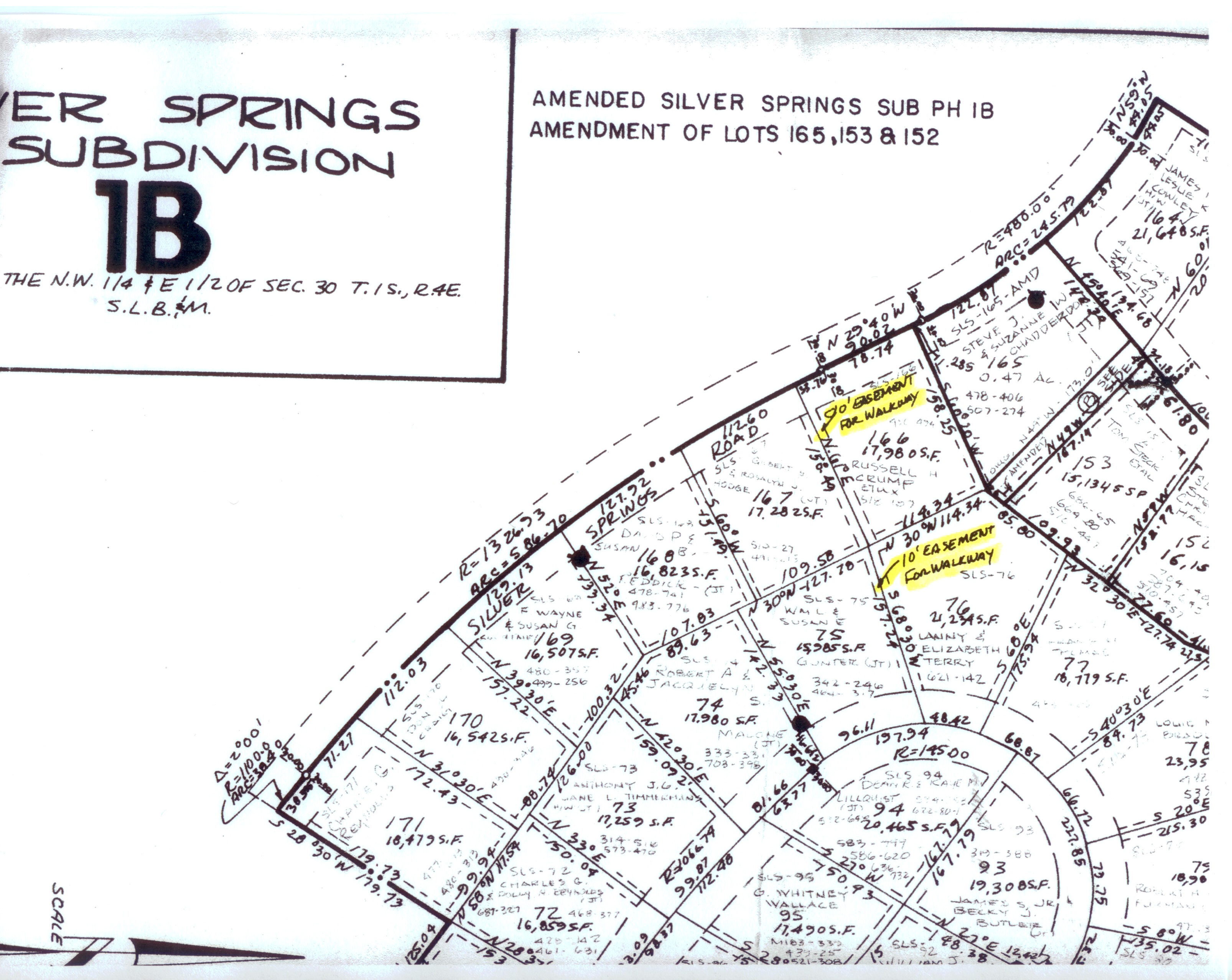
Reports the 1982 Planning Commission approved common access points to the lake as Parcel H, Parcel R and also an area at the north end near Parcel T (originating at Willow Loop Lots 75 & 76 to Silver Springs Road Lots 166 & 167- see Plat 1B). Parcel K was not noted. Another SS Master Plan was approved in 1978-1979 by the Summit County Planning Commission.
Parcel K aka PP-98-A-2-A Entry 00216088 QCD on January 24, 1984 from Ray Fry of RDF to development company InSource.
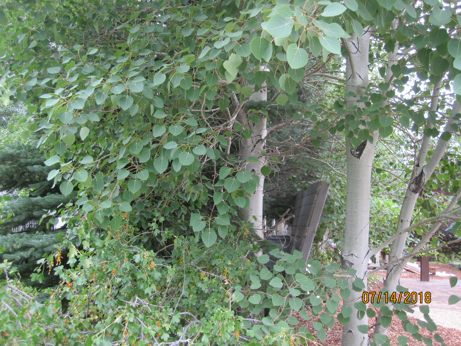
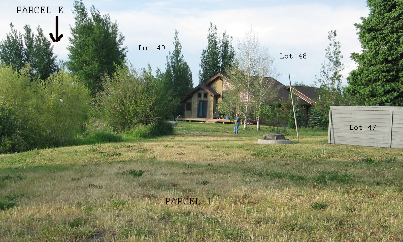 —PARCEL K is tucked in between Lot 49 and Lot 193 (outside of photo on left).
Parcel I Beach along photos center shoreline.
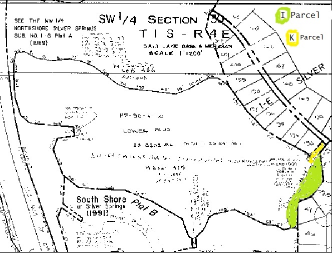 1988 Summit County Section 30 plat map shows Parcel K lake access and Parcel I beach area
Other Lake Access Parcel descriptions are Parcel I and Parcel W that includes information on the Exclusive Private Enjoyment Easement. At the bottom of this webpage is the description of the abandoned access pathway from Willow Loop , between Lots 75 & 76, then between Lots 166 & 167, to Silver Springs Road, then between two lakefront lots 198 & 199, to the lake.
*Morris & McComb Real Estate Sales handout c.1982– Cyndi Sharp, agent.
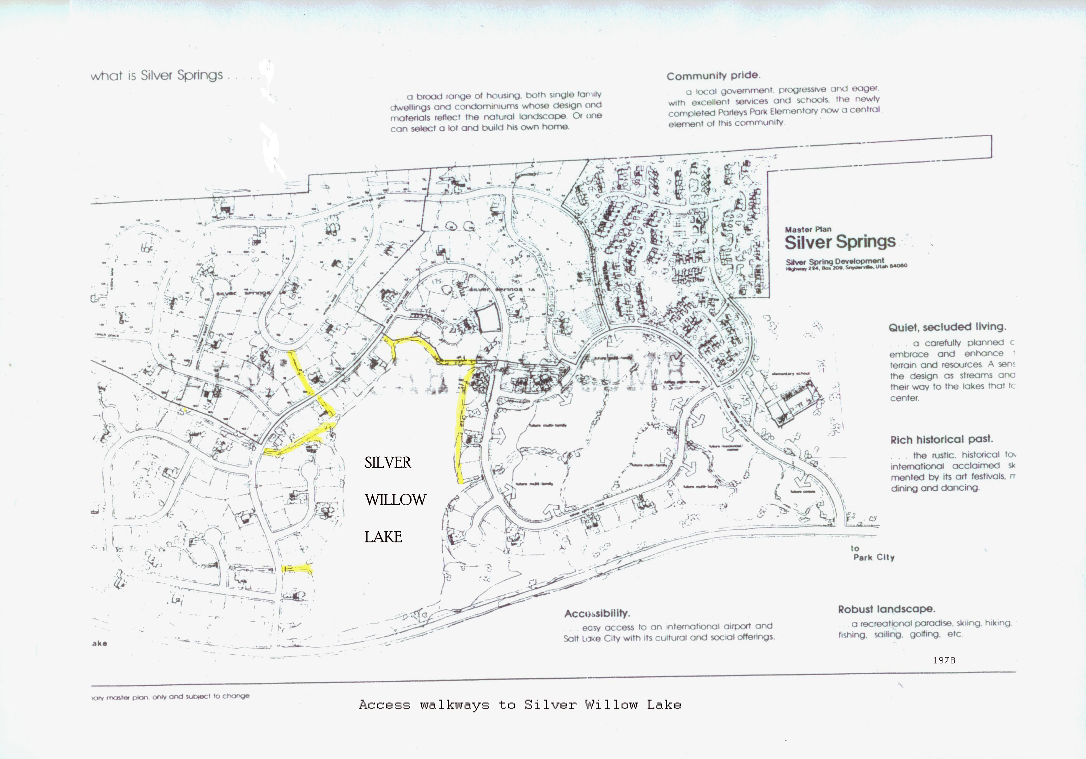
**Walkways for access to the Silver Willow Lake aka the Big Lake
Snyderville Basin Water Reclamation District c.2008
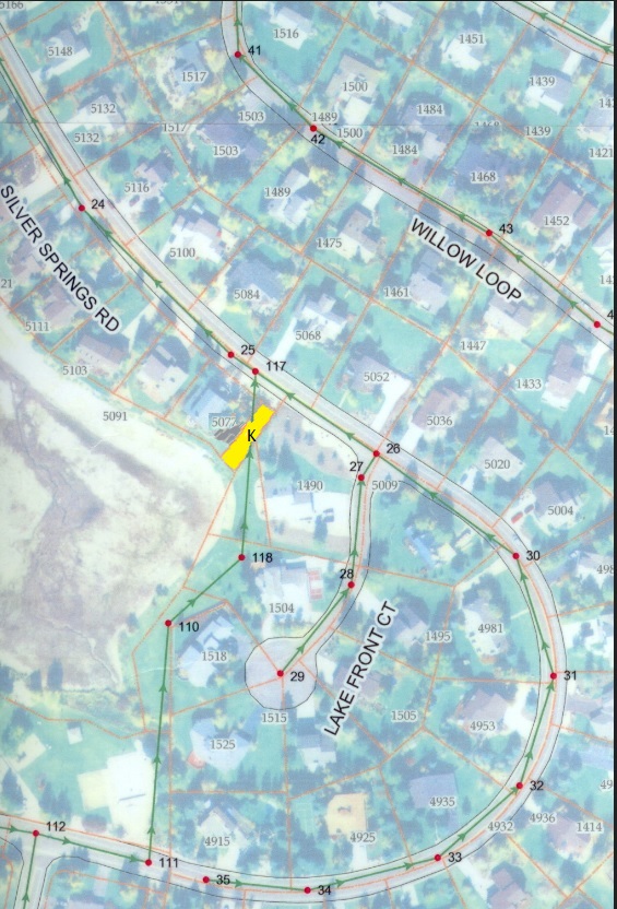
Parcel K shown between addresses 5077 (Lot 193) and 1490 (Lot 49), both on Silver Springs Road
| Parcel Number PP-98-A-2-A (Joined to SLS-1E-193) |
| Account Number 0216451 |
| Tax District 10 – PCSD A,J,K,U (C-C) (E-E) |
| Acres 0.06 |
| Situs Address 5077 Silver Springs Road |
| LegalS 30 T 1S R 4E BEG AT THE MOST E’LY COR OF LOT 193 SILVER SPRINGS DEVELOPMENT NO 1-E; ACCORDING TO THE OFFICIAL PLAT THEREOF; ALSO BEING DESC AS N 2272.398 FT & E 2554.540 FT FROM THE SW COR OF SEC 30 T1SR4E SLBM; TH S 36*03’20” W ALONG THE E’LY LOT LINE OF SD LOT 193, 100.67 FT; TH S 37*00’00” E 28.24 FT; TH N 35*00’00” E 109.16 FT TO THE S R/W LINE OF SILVER SPRINGS RD SD PT ALSO BEING ON A 1356.93 FT RAD CUR TO THE RIGHT (RAD PT BEARS N 35*00’00” E) & RUN TH NW’LY ALONG SD CUR 25.00 FT TO THE PT OF BEG CONT 0.06 AC (PARCEL 7-A) M232-443 M259-555 288-471 409-605 497-280 667-316 (REF:668-361) 1533-2861609-1187 |
Parcel K : PP-98-A-2-A Common area, lake and Enjoyment Easement access parcel at Silver Springs Road between Lots 193 and 49 in Silver Springs. Begins at the lake rip rap and continues east to Silver Springs Road; 25 foot wide access easement. Aka PP-98-A-2-A, Entry 00298852 Book 497 Page 280 Recorded on October 17, 1988 as deeded by American Savings & Loan to William C. Ligety and Cynthia Sharp.
1989 – September 18 –Silver Springs Board Minutes by Bonnie Adams:
“Bill Ligety’s new fence was discussed. The land being fenced is the Parcel purchased from American Savings. The fence is 7′ tall. Our guidelines say 6′. In addition, this same parcel is according to Lynn Stevens, a necessary easement for the Water Company to the lake and was a highly debated issue last year. According to Bill, the SSHOA has no jurisdiction over this parcel as it is not part of the SS subdivision plat, and he can therefore do as he wills. He is keeping the fence level with his other which is 6’4″, another violation, to be consistent with the design because the lights and neighbors bother him. According to the County he did not get a building permit as required. Rick Hovey will check out the Title Company to find out if Bill Ligety is correct before we take our next coarse of action –annexation. This issue will be pursued. S.S. Attorney Scott Welling will be consulted on an as needed basis. ”
| Entry Number | Form Name | Recording Date |
| 00693858 | Gurman to Fuller | 04/01/2004 04:31:00 PM |
| 00657473 | Jay to Pam Gurman | 05/08/2003 01:01:00 PM |
| 00360504 | Ligety to Gurman | 06/12/1992 04:01:00 AM |
| 00298852 | AmSav. to Ligety | 10/17/1988 02:01:00 AM |
| 00262052 | AmSav. to AmSav. | 12/12/1986 11:30:00 AM |
| 00216088 | RDF to Insource | 01/24/1984 04:29:00 AM |
RDF Associates QCD on PP-98-A-2-A to InSource, Inc. on January 24, 1984 Entry Number 00216088.
It is believed this parcel was a resulting remnant when the Hardman’s subdivided the 857 acre Silver Springs East development. The intent was to use this location as a water company easement. Ligety, and later Lynn Stevens, director of Silver Springs Water Company, confirmed the original purpose of this parcel was to be used as housing or access to the pumping equipment to be used by the water company in providing irrigation water to the homeowners. The location was subsequently changed to Park Parcel H. for the pumping equipment.
InSource, Inc. (Mike Hardman, Scott Hardman, Dick Pierce, John Perry?) to American Savings & Loan Association. Bankruptcy requirement.
American Savings and Loan Association deeded PP-98-A-2-A (SS Parcel K) as an exclusive perquisite purchase on October 17, 1988 to William C. Ligety and Cynthia Sharp. Entry 298842 (298852) Book 497 Page 280.
William C. Ligety and Cynthia Sharp (SLS-1-E-193 ) then deeded PP-98-A-2-A on June 6, 1992 to Jay and Pamela Gurmankin, Entry 360504.
Pamela M. Gurmankin deeded PP-98-A-2-A on June 6, 1992 to Harry Fuller and Janet Goldstein,
April 1, 2004 Entry Number 00693858
ALSO BEING DESC AS N 2272.398 FT & E 2554.540 FT FROM THE SW COR OF SEC 30 T1SR4E SLBM; TH S 36*03’20” W ALONG THE E’LY LOT LINE OF SD LOT 193, 100.67 FT; TH S 37*00’00” E 28.24 FT; TH N 35*00’00” E 109.16 FT
1988 – ACCESS FROM WILLOW LOOP TO SILVER WILLOW LAKE AND PEDESTRIAN TRAIL : “Dale Boshetto, president of the homeowners association in Silver Springs, said that in 1982 it was stated at a homeowners association meeting that the entire lake shore would be available to all property owners…via the continuation of multiple access points for the enjoyment of this amenity by all property owners… The lake is a fishery and cannot be blocked, anybody can access this lake…
Mr. Boshetto said on plat 1B there is a walk way between lots 75 & 76 on Willow Loop Road and 166 & 167 on Silver Springs Road that would make a natural continuation to the lots in plat 1E. Plat 1E was not platted with a continuation of a walk way…. ”
The since abandoned access pathway from Willow Loop , between Lots 75 & 76, then between Lots 166 & 167, to Silver Springs Road, then between two lakefront lots 198 & 199, to the lake is indicated on several maps and on this SSSF Plat 1B.
The multiple points of lake and trail access are supported in the approved Master Plan.
See access points on this early map: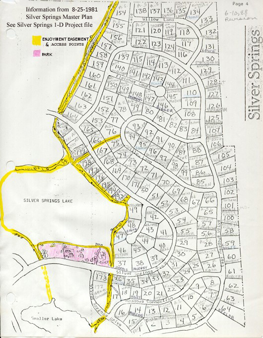
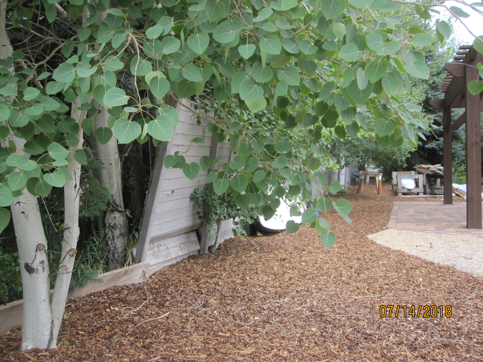
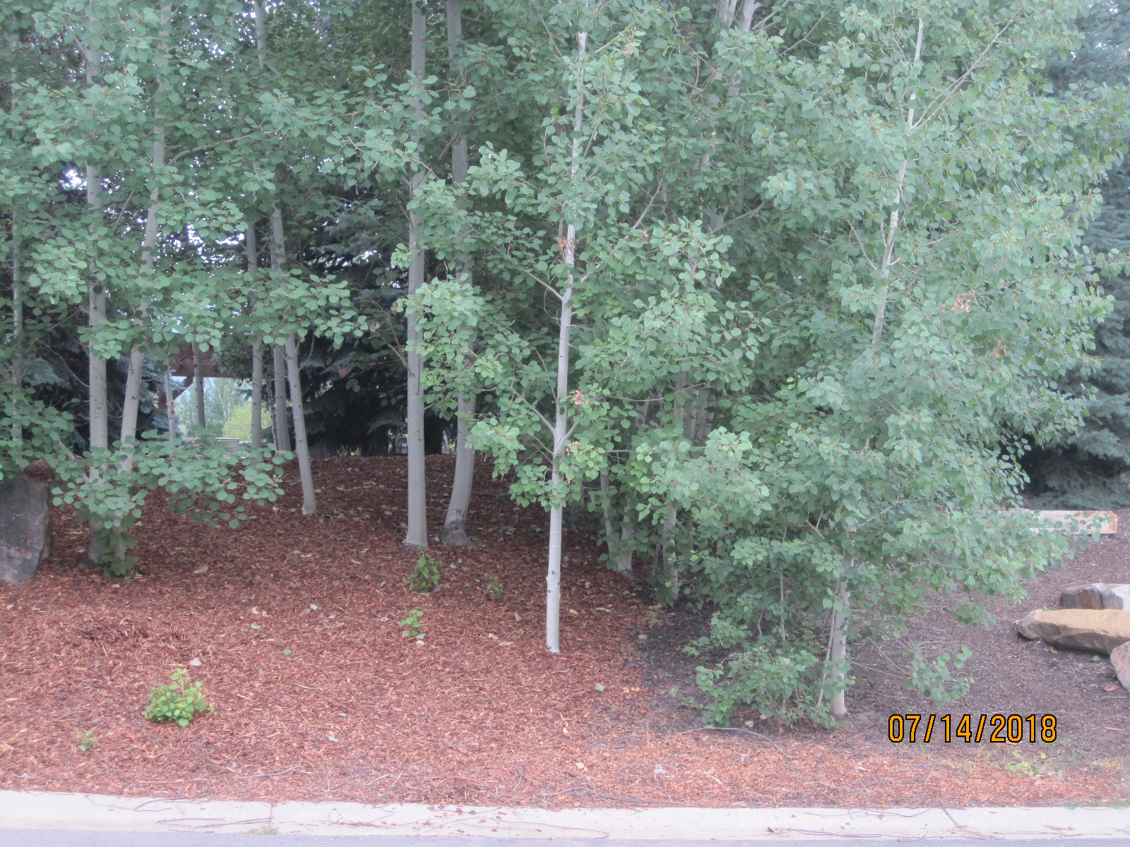 Parcel K- 2018 View from Silver Springs Road |
 Parcel K- 2018 View from Silver Springs Road |
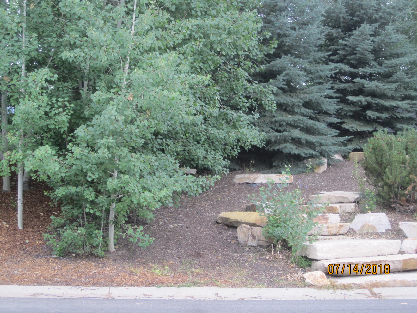
 Parcel K- View from Big Lake perimeter trail Parcel K- View from Big Lake perimeter trail |
 Parcel K-View from Big Lake perimeter trail |