—Silver Springs Dams
Silver Springs Lakes Dams
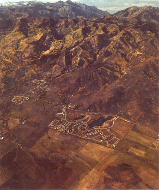
Silver Willow Pond (6510 feet above sea level) and Silver Willow Lake (6480? ft above sea level)
Note that Parley’s Park Elementary School, The Blue Roof, Silver Meadows Townhouses,
Quail Meadows Condos and Willow Bend Village are in photo.
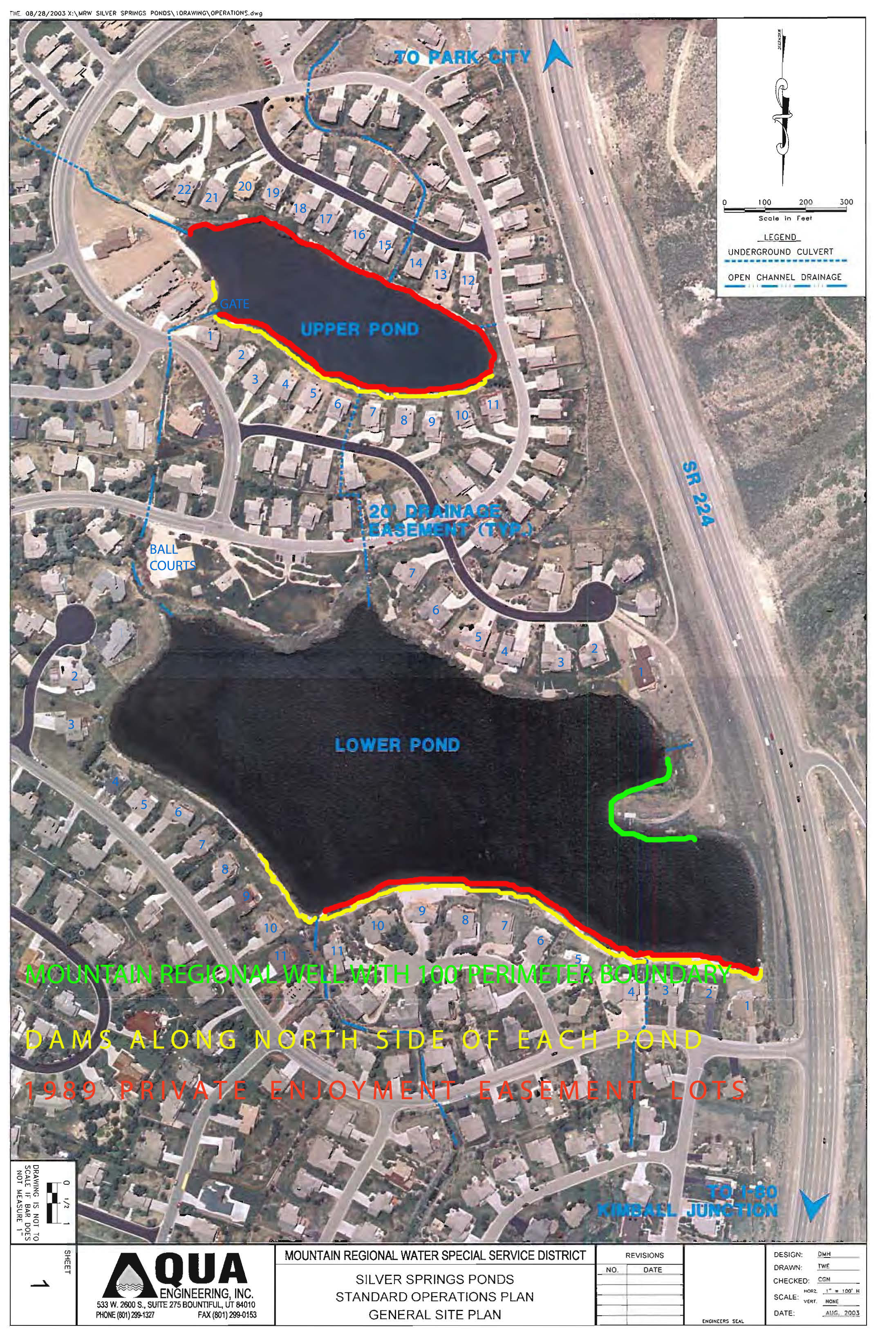
The north side (right side of water bodies) of both lakes shows the built up areas (light tan banks) now known as the “dams” = NorthShore Lots 1-12 and SouthShore Lots 1-13.
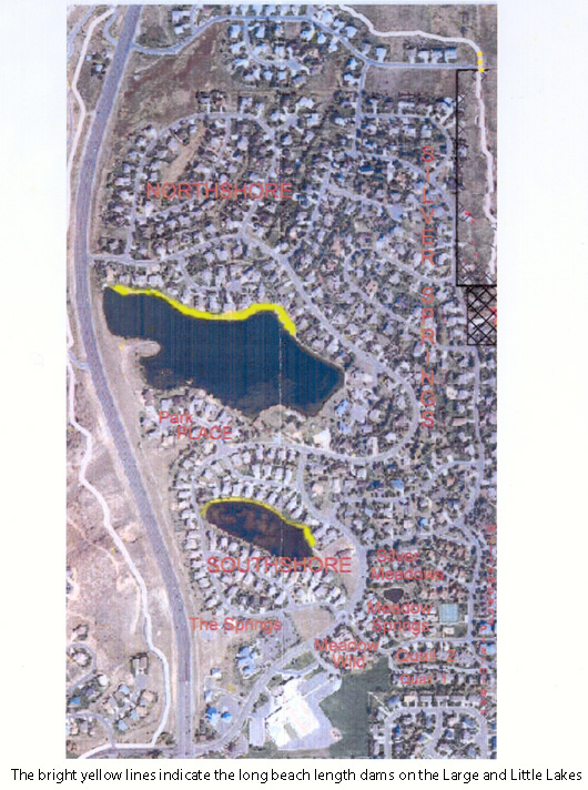
Berm in center of photo is example of a section of the north dam of Silver Willow Lake (Parcel F)
Between Lot 196 (Robinson) and Lot 197 (Zehner) lies the large lake dam right abutment.
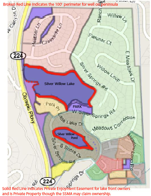
The above sketched map represents the Enjoyment Easements as they were thought to exist between 2005-2008.
Silver Willow Pond is surrounded by a 1989 Private Enjoyment Easement Agreement that was recorded on the 1991 SouthShore subdivision plat map. This Agreement provides access and use of the perimeter of either lake only to the 24 or 25 small lake view lot owners and 11 large lake view owners (36 total). The 1989 Exclusive Private Enjoyment Easement applies only to the 11 or 14 Northshore lots formerly owned by Michael Barnes.
Silver Willow Lake Enjoyment Easement perimeter originally intended for ALL Silver Springs Community property owners has been relegated over the years for the contiguous lake front property owners. From 1990 to the present, the 443′ Park beach area has been the only access to the Silver Willow Lake usable by ALL 504 Silver Springs Community property owners.
2004 – Transfer of Ownership – Letter from Richard B. Hall, Assist. State Engineer. Instructions on use and maintenance of these dams. These lakes have only evaporative Water Rights. …..John Mann, Department of Water Rights, Regional Water Engineer.
2005 – May 18 – Letter to Lake Front Property Owners from Anthony Sands, President of the SSMHOA: “As I am sure you all know, the private property owners on the lakes do not own the property that contains the lakes, or the lake shore. The lots in different subdivisions have different setbacks from the lakes. In all cases however, the Master Association owns the ground under the water and the lake shore going up the dam to include the crest of the dam.” [NorthShore lots 1-4 and 6-12, Park Place lots 38-44 (not Barnes lots?), and SouthShore lots 1-11 and 50-60 that surround the Little Lake, of these however NorthShore lots 1-4 and 6-12 and SouthShore Lots 1-11 back onto one or the other dams. The dam is the north side of the Exclusive Private Enjoyment Easement on both ponds/lakes.]
2006 – Nov 27 — Dam #1 Repair Inspection letter from Jerry D. Olds, State Water Engineer.
2008 – July 3 — Dam Inspection Report signed by David K. Marble, Assist. State Water Engineer
Email to Lucy Archer: “Concerning time frames/deadlines for action. The Silver Springs dams are inspected every two years. During each inspection followup on what has been completed since the past inspection occurs. From my experience with the dams the MA is doing a fine job working to comply with the inspections.Concerning property lines, my understanding is that the MA owns the property approximately 25 feet back from the high water level.Sincerely,
Everett W. Taylor, P.E.
Division of Water Rights, Dam Safety1594 W. North Temple Suite 220
P.O. Box 146300
Salt Lake City, UT 84114-6300
Office: (801) 538-7372
QUESTION: If “the MA owns the property approximately 25 feet back from the high water level” then why is it that the Members cannot use this lake perimeter property?
Read the 1989 Enjoyment Easement Agreement. Can this Agreement be challenged by the MA? It is not a recorded document. except perhaps on individual deeds.
DAMS BACKGROUND: In 1979-1980 the Silver Springs lakes (“ponds”) and dams were formed by compacted soil and gravel with the efforts of the Hardman’s and Spencer’s.The north rim elevation of the large lake is 30′ lower than the south rim of the little lake therefore the north rim dams on both “ponds” are higher than the south rim of each of the two larger “ponds”. The two dams, the water gates and outlets had received little maintenance from original owner Robert Larsen and the Silver Springs Water Company, and the subsequent owner Mountain Regional, up to 2004, a period of 24 years. The State Water Division has classified these two dams, approximately 1200′ long, as “medium hazard dams”. This is determined by the amount of property damage that could occur if a breech occurs and a dam fails. The houses built along the large lake dam, NorthShore lots 1-4 and 6-12, and Silver Springs lots 197-199, would likely be the first affected. However, an event the size of an earthquake is the only event listed to potentially be the cause of a breech. An earthquake would potentially cause damage as well to homes not near the lakes or dams. Activity of the water itself is very low as there are no motor crafts creating waves, the inlet stream is quite benign, so any buffeting against the shoreline is quite minimal. The SSMA (Master Association) has reported its ownership of the perimeter of both lakes. This perimeter is between 15′-25′ from the water line (rip rap) to the back lot property line of each lake front private property, except for lots where property owners have gained ownership to the water line. (On April 13, 2010 the lake front property owners of lots 193 (Fuller), 194 (Hedges), 195 (Carriel), and 196 (Robinson) petitioned the SSMA board to allow them to also absorb into their lots the lake perimeter land between their back lot lines and the water line.) The fact that some lake front property owners own the land (aka the dams) to the water line translates that individual lake front property owners own (are) the dams. The SSMA owns what? the smidgens in between. In effect, the lake front houses are a part of the dam profile. Most of the SSMA assessment to ALL 504 SSMA individual property owners pays for the maintenance, insurance, repair, and management of the lakes, their perimeter, and the lake dams which have become the property of the FEW contiguous lot owners. The non-lake front owners have been excluded from the use and access to the entire perimeter of either lake except the 443′ along the Park. On the SouthShore recorded 1991 plat the small lake has an exclusive Exclusive Private Enjoyment Easement giving the little lake perimeter (not including Ross Lloyd pocket park), to the small lake owners. This 1989 Private Enjoyment Easement document gives the whole lake’s perimeter easements for BOTH lakes exclusively to the lake front owners property originated from developer Michael Barnes.
—August 2, 1989: “WHEREAS Grantee [Silver Springs Associates] desires that purchasers of residential lots bordering the Silver Springs Ponds (the “Lakeview lots”) have exclusive private enjoyment of the Shoreline Property adjoining their respective Lakeview lot.” In 2004, through the efforts of Eric Fraleigh and Les Carriel (both are lake front owners) and County Commissioner Bob Richer (Meadow Wild condo owner), a Lake Conveyance Agreement was signed only by the president of the SSMA (Anthony Sands) without the knowledge or vote of the property owners who through this agreement were made indebted annually to finance the maintenance, insurance, property taxes, repair, and management costs for the two lakes and the two dams. This Agreement transferred ownership and liability for the lakes to the SSMA membership, and to the Silver Springs property owners, from Summit County’s Mountain Regional Water Special Service District, therein written to hold the County harmless. Gunter blurted out at the October 13, 2010 meeting that there is now a letter that passes the liability of the lakes and dams from the SSMA directly to the individual property owners. Noland told Gunter to table further comment. We have requested a copy of this letter from Bill Noland but so far have not received a response.
The one-sided 2004 Lakes Conveyance Agreement written by Summit County lawyers states that Mountain Regional owns the water in the lake and retains a number of rights but does not contribute to its cleanliness, maintenance, liability or environmental condition. If there is a breech of the dams it is the water owned by Mountain Regional that will cause damage to the homes in the acknowledged inundation plain yet t Mountain Regional does not contribute to the expense of the liability insurance paid by the property owners through the SSMA. The water is not considered safe for swimming, the trout population has been nearly decimated by the foulness of the water, but the water can be used for firefighting via helicopter bucket. The County therefore benefits by having this amenity for their potential use but does not share in the liability nor the burden of the costs to insure and maintain these bodies of “firefighting” water. In this situation the property owners rights have been put at risk without being allowed their right to vote. The State Water Division Dams Department provided a report on their inspection of the dams and issued a report as noted on the October 7, 2009 letter posted above. The SSMA has reviewed the report and is contacting lake front property owners to remove trees and other vegetation they have planted on the crest of the dams. Once the homeowners have complied then the cost of the work required to bring the dams up to the State’s standards can be correctly determined. Originally the estimated work required was expected to be more than the available SSMA funds. On February 9, 2010 the SSMA announced they were requiring a 200% assessment for work on the private little lake without correctly gathering property owner votes as required by the SSMA Bylaws and the NorthShore, SouthShore, and Silver Springs SF CCRs. This assessment was met by great protest of the non-lake front property owners. By August, and with the intervention of Kristian Mulholland, an engineer and SSSFHOA board member, the dam and gates cost of the work was greatly diminished with the approval of the State Engineer’s Office. The disposition of the excess assessment fees collected from the property owners was discussed by the SSSF board and Bill Noland. (See Sept. 7, 2010 Minutes.)
THREATS TO THE DAMS. The one word that always comes up first when speaking of the dams and lakes is Liability. On February 9, 2010 the SSMA displayed an inundation map provided to them by the State Division of Water Rights. This map shows the area calculated to receive flood water should there be an earthquake that breeches the dam. Of course, first to go would be the houses built on the dam (NorthShore lots 1through 12) next the houses directly north of Lake Front Court in the NorthShore subdivision. This scenario and map is used by the SSMA as they straddle the issue of justifying assessments to all property owners to pay private lake and dam assessments. In the event of an earthquake does the SSMA have liability insurance for non-lake owners homes who may be damaged or destroyed by the earthquake?On the other hand, the likelihood of a dam breech is close to microscopic. Herein lies the tug of war between neighborhood property owners. The lake front owners are very active in all the SSMA and subdivision HOAs in order to protect their own interests for an amenity they exclusively hold and to jockey for the inactive majority Community members to pay for it.
Liability has other faces, there is the concern about someone drowning and the possibility of a lawsuit that would assess each property owner 1/495th part of a million dollars ($202,020.20) possibly not covered by the SSMA insurance.
There are many NorthShore and other Community property owners who side with draining the large lake and using the 20.84 acres of ground for a neighborhood park that can and would be used by all contributing owners. This latter group has to become more vocal and insistent or they will be forever paying for lakes they do not and cannot use.
Eighty-nine percent of the 2010 Survey Ballot respondents voted on Item 4 that the non-lake front owners were not to be assessed for lake costs and that the SSMA cannot raise the annual fees without property owner 66 2/3% voted approval. The SSMA has so far chosen to ignore the wishes of the property owners.
MAINTENANCE: The land under the water, SSMA property, and the water (belonging to Mountain Regional) quality itself is a tremendous challenge as the flow from upper elevation land includes great amounts of phosphates (from lawn fertilizer) and general sludge. The phosphates feed the milfoil, coon tail, and other water vegetation so that they grow at accelerated rates. These plant’s roots break up the compaction of the dam and compromise the dam profile. The root systems can create tunnels in the dam soil that water can flow through. The construction of the golf course at The Canyons along with their use of fertilizer is expected to greatly increase the problems with water vegetation growth. Also as the water plants grow, die, and then rot, the water becomes clouded and the air around the lake can have a putrefied odor. Chemicals are being applied to the water but are difficult to retain as the water flows north through NorthShore and onto the Swaner Nature Preserve, etc.
We are told water seeking plants on the ground (aspens, willows, cottonwoods, etc.) are a detriment to dam compaction. Growth of vegetation along the dams’ north rims of the lakes could weaken the compaction making them more vulnerable should an earthquake occur.
Another concern is burrowing animals, pot guts, moles, voles, field mice, that may enjoy the grassy habitat around the lake perimeters. Their tunnels and tracks may serve as conduits for water penetration into the beach area dams causing erosion or swamping of the basements or crawlspaces of the homes built on the dams.
The SSMA has reviewed the status of each lot on the dams to confirm they are in compliance with the requirements listed in the letter posted above. If the lake front property owner installed a structure on the dam in the past and that structure is considered to have compromised the dam compaction then the SSMA is expected to recover the cost for repair from the lake front property owner.
HOMEOWNER DISSATISFACTION Another consideration is that there is increasing dissatisfaction from non-lake front property owners with the arrangement regarding not only the assessments they must bear for the lakes’ dams, gates, maintenance, and management, etc. but also with the liability being accepted by the SSMA on behalf of Silver Springs property owner without notification to all the property owners or their vote. When the large lake was first dredged and filled, all the Community subdivision property owners had the right to walk or bicycle around, sunbathe, picnic, or fish along the entire perimeter of the large lake. As newcomers bought lake front lots and built their homes they sought to eliminate neighbors walking past or using the common area Enjoyment Easement beyond their back lot lines located between them and the large lake.
Around 1988 Bill Ligety (Lot 193) was successful in convincing American Savings to sell him the 25′ wide east lake easement, Parcel K, from Silver Springs Road that ran along his south lot line to the lake. He extended his fence to include this easement parcel and cut off access to the lake from its east side. Parcel I was then absorbed by Lots 47, 48, and 49. Piece by piece the approximate 43,222 linear foot large lake perimeter easement has been impinged to reduce large lake access to 443′ along the Lake Park. Four owners, Robinson, Carriel, Hedges, and Fuller have petitioned the MA to sell to them the land from their back lot line to the water line.
In 1991 developers recorded a plat for SouthShore subdivision that gave the perimeter of the little lake owned by the developers (Barnes and Widdows) to the contiguous lake view owners, this does not include the 6 Little Lake properties, documented in the 1989 Exclusive Private Enjoyment Easement document . Because of this easement, no access or trail can be developed on the perimeter of the little lake.
Mountain Regional maintains a well on the peninsula on the west end of the large lake, they have a 100′ easement along the west side of the large lake that precludes access (which is now gated and locked) and use by the Community property owners.
In a Community Survey Ballot collected in April and May 2010, on Item 3, 91% of the 212 respondents voted that the SSMA shall be divided into three districts, each assessed according to the amenity that is closest to them. Non-lake front owners are becoming increasingly discontent to watch as access has diminished while the assessments have increased. The SSMA is in flux at this writing and we expect that the whole organization will be revamped on November 9th or December 5th, 2010 (another move without property owner input or vote?). The Community Group has provided many suggestions and input which is yet to be addressed or responded to by the SSMA board.