— MA – PARCELS INDEX :
Silver Springs Community
Common Area Parcels
The member subdivisions of the Master Association are listed on the
SILVER SPRINGS COMMUNITY SUBDIVISIONS web page.
The Recreation Areas on an Interactive
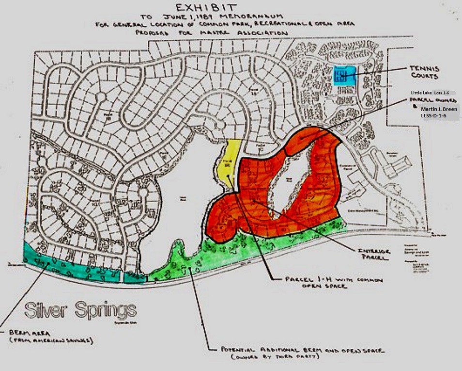
1988 – June 7 – Trustee Meeting Minutes-HOA President Dale Boschetto showed us a master plan map dated “preliminary approved 8-25-1981″ that he found at the county offices. He photocopied it and Jerry Smith, of the county planning office, signed it, dating it 6-6-88 showing common area around the lakes, and two access paths across Silver Springs Road, etc.” A copy of this master plan map will be kept in the Association secretary’s permanent files.
1988 – August 8 – Letter from American Savings Attorney Ryan Richards regarding Silver Springs Parcels.
SS COMMUNITY Parcels and Subdivision Map
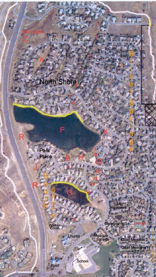 Bright yellow lines are the lake dams.
The Master Homeowners Association Parcels:
“The general purposes and objectives for which this corporation is organized are to provide an organization which can (1) hold title to, lease, and acquire easements or other rights of use with regard to specific parcels of real property which are to be used as common recreational areas for all homeowners associations which are members of the Silver Springs Master Homeowners Association; (2) manage those common recreational areas for the benefit of all its members;…..”— 1990 Articles of Incorporation.
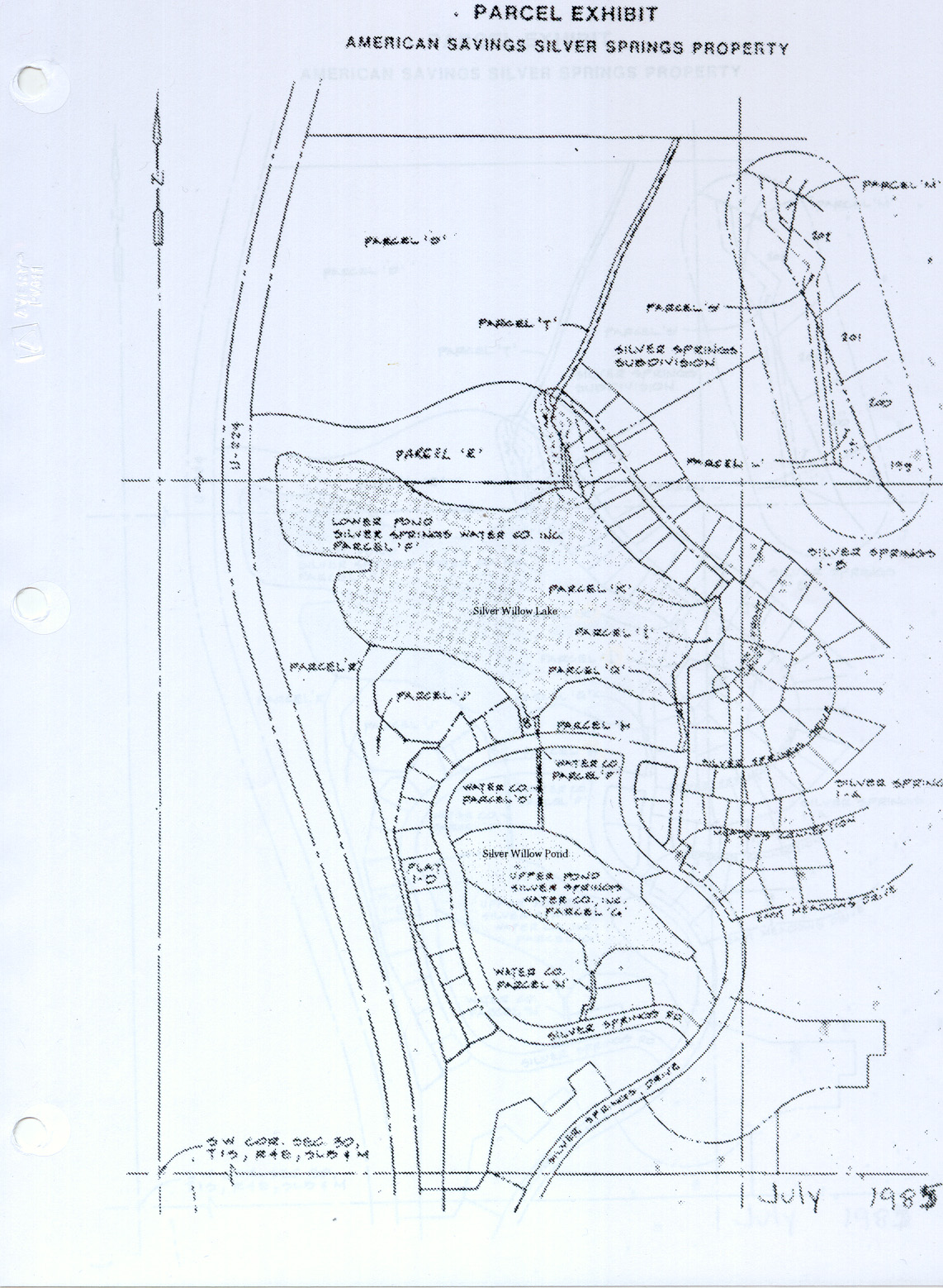
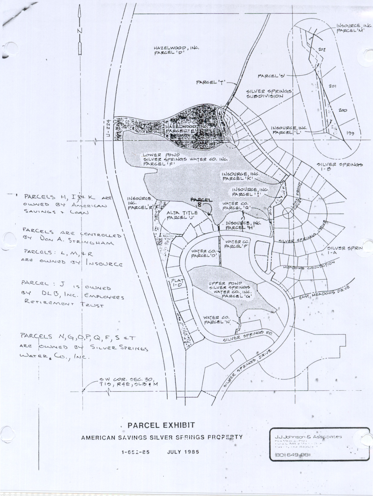
In 1985 Parcels F, G, N, O, P, Q, S, T, were owned by the Silver Springs Water Co. These are inlet and outlet stream and pond parcels. Commencing in 2004 Mountain Regional owns the water and rights in Silver Springs; the Master Association owns the banks up to the rip-rap and the ground under the water, and the responsibility to maintain, insure, repair, manage not only common area land but also the land under the water.
1987 – October 21 – Associated Title Policy for Warren Spieker, Jr., Michael S. Barnes, and Richard Widdows named the title interest in eleven parcels within Silver Springs received from American Savings and Loan Association. Commitment Number M13173,
Parcel 1 – PP-98-A-3-A
Parcel 2 – PP-98-A-3-B
Parcel 3 – PP-98-A-1
Parcel 4 – PP-98-A-5-B
Parcel 5 – PP-98-A-5-C
Parcel 6 – PP-98-A-5-D
Parcel 7 – PP-98-A-7-A
Parcel 8 – PP-98-A-5-A (also known as Parcel B)
Parcel 9 – PP-98-A-7-C
Parcel 10 – PP-98-A-8-B
Parcel 11 -Serial No. SLS-1D-174-185
1988 August 8 – American Savings Parcels letter from Ryan Richards. Some Silver Springs Parcel descriptions are listed in the 1989 Developer-Homeowner Agreement for the Silver Springs Subdivision in Exhibit “A”, Exhibit “B”, Exhibit “C”, Exhibit “D”. Also see: 1987 Letters regarding Parcels H, I, K & B.The Silver Springs Community is partly comprised of :
-Silver Springs Single Family subdivision Phases 1A, 1B, 1C, 1D (Little Lake), 1E
-South Shore Single Family subdivision is made up of Silver Springs Phases remainder of 1D, 1F
-North Shore Single Family subdivision is made up of Silver Springs Phase 1G
-Seven Condo-Townhome subdivisions with 126 residential units.Note: The “Flag Parcel” at the south entry to Silver Springs, on the south side of Silver Springs Drive belongs to Home Savings Bank. (Home Savings Bank Parcel Number HSBSPA-A is 0.83 acres). Home Savings Bank allowed SSMHOA to build an entry monument sign on the corner and to have the three flag poles situated on this land. This is also the site of the original Samuel Comstock Snyder Grist Mill. Under the Hwy 224 is the convergence of the three streams that worked the sawmill (west of Hwy 224) and the gristmill; Spring Creek Spring, Red Pine Stream, and Willow Creek Stream.
The MA Parcels according to the 1985 American Savings Parcel Exhibit Map:
Though all these parcels exist within the Silver Springs Community they are not all deeded to the Silver Springs Master Homeowners Association, some are drainage easement parcels belonging to contiguous individual lots. Drainage easements will be noted on the Parcel as reported to the webmaster. This list and its parcel links represents an inventory of waterways, common areas, and open space within the Silver Springs Community.
Parcel A : Common area easement parcel/ outlet stream, beginning from under Silver Springs Road at 20′ wide between North Shore Lots 28 & 29, commencing north, and widening to 40’+ then narrowing as it reaches Heather Lane between North Shore Lots 64 & 83.
Parcel B or 8 : Common Area Beach on south end of Silver Willow Lake adjoining Parcel P and Park Place Lot 44, etc.
Parcel C : Federally protected “Wetlands” NSS-B-WOS, approx. 0-87 acres. Open space parcel north of Hazelwood parcel D. Between North Shore Lots 39 & 40, north to Cutter Lane and west approximately 500 feet from Heather Lane to Highway 224. Parcel is wider at the north end. Contains a couple small ponds occasionally visited by moose and elk.
Parcel D : NorthShore Silver Springs No. 1-G Plat B (NSS-B-Lot #). Acreage owned by Hazelwood, became southwest section of NorthShore.
Parcel E : NorthShore Silver Springs No. 1-G Plat A (NSS-A-Lot#). Hazelwood Parcel became the portion of NorthShore directly north of the Lower Pond (Silver Willow Lake) on North Shore Court and the west portion of Silver Springs Road.
Parcel F : the Lower Pond aka Silver Willow Lake aka PP-98-A-10 is 20.84 acres.
Parcel G: the Upper Pond aka Silver Willow Pond aka Duck Pond aka the small Silver Springs lake aka PP-98-A-6 is 5.24 acres.
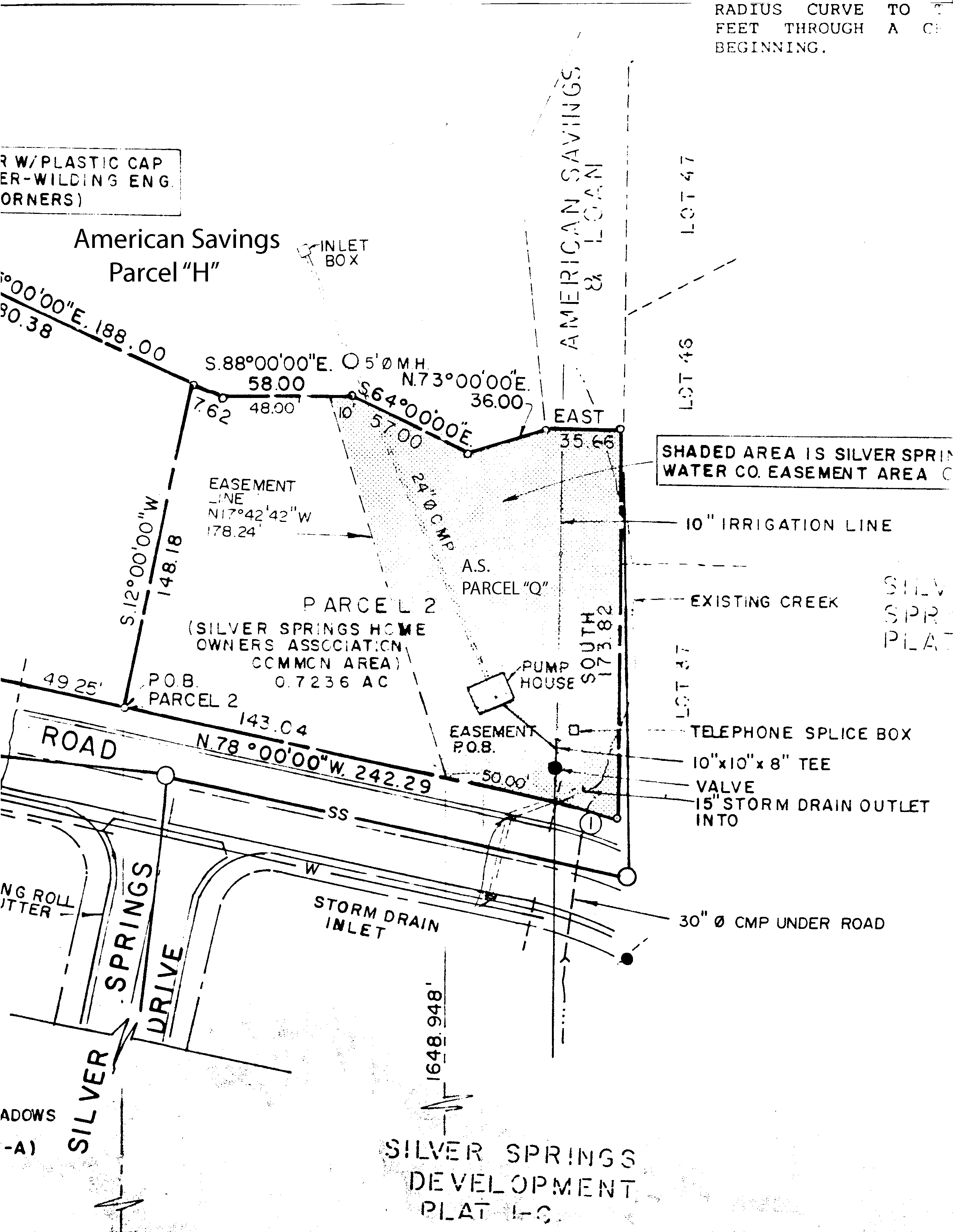
Parcel H: the Silver Springs Community Park aka SOS-A-Park is 2.01 acres and includes the pump station parcel PP-98-A-1-A.
Parcel I : InSource, Inc. parcel designated as common area beach along the southeast border of the Silver Willow Lake adjoining SLS-A-Lots 47, 48, 49, and a part of the pedestrian trail around the circumference of Silver Willow Lake. It is believed to be part of the Enjoyment Easement around Silver Willow Lake. The Master Association in 1993 divided this Parcel I into three parts then sold each part to the three owners of the three contiguous lots.
Parcel J : Common area parcel beginning at southwest border of the Lower Pond, continuing down to the bottom of SouthShore’s plat D west of Lot SOS-C-69. Is now designated as part of Parcel R, and also known as part of SOUTH-BERM.
Parcel K : PP-98-A-2-A Common area, lake and Enjoyment Easement access parcel. Twenty-five foot wide access easement between Lots 193 and 49 in Silver Springs. Begins at the lake rip rap and continues east to Silver Springs Road. Aka PP-98-A-2-A Entry 00298852 Book 497 Page 280 Recorded on October 17, 1988 as deeded by American Savings & Loan to William C. Ligety and Cynthia Sharp.
Parcel L : Former InSource, Inc. property. Common area triangular parcel bordered on west by Parcel S easement, bordered on east by Silver Springs Lots 199, 200, 201. In June 2005 a new plat was recorded showing this parcel divided into north and south portions. The north portion was joined to NSS-A-12 though a portion of Parcel S separates it from Lot 12 and NSS-A-12 was reassigned a tax I.D. number of SLS-E-12.
The south portion of Parcel L was joined to SLS-E-199 but allowing eleven or so feet from Lot 199’s north boundary. This may have been left to allow for the common area easement that was present as access to the Lower Pond from Silver Springs Road between SLS Lots 199 and 200. This easement then allowed the general membership access to the lake, use of the Enjoyment Easement and use of parcels S and T along the banks of the stream.
Parcel M : Common area irregular rectangular parcel bordered on west and south by Parcel “S” easement, bordered on east by Silver Springs Lot 202, and bounded on north by Silver Springs Road. At this time, as far as we can tell, this parcel has been absorbed by SLS-E-Lot 202
Parcel N : Inlet stream parcel (White Pine stream?) originates in our community through underground pipes and opens on Silver Springs Drive, flowing north between SOS Lots 75 & 76 follows the back lot lines to point of SOS Lots 70, 71, & 80, flows under South Shore Drive and between SOS Lots 57 & 58 then into the Upper Pond a.k.a. Silver Willow Pond.
Parcel O : An inlet stream parcel begins at Parcel G aka the Upper Pond aka the smaller lake, runs north through South Shore to and under Silver Springs Road (west side of Community park).
Parcel P : An inlet stream parcel that is an extension of Parcel O. Begins where O ends, and continues north to the Silver Willow Lake. Found between Park Parcel H and Beach Parcel B.
Parcel Q: Inlet stream parcel from Little Lake, under Silver Springs Drive, runs along the water channel Parcel Q Creek easement, also along Parcel V (known as the Dick Mitchell Memorial Park); then runs north under Silver Springs Road on the east side of the Silver Springs Community Park Parcel H, to the Silver Willow Lake rip rap.
Parcel R: Common area parcel begins on the corner of Silver Springs Road and Highway 224 where the Silver Springs/NorthShore monument entry sign is situated, then runs south along Highway 224 berm all the way to the north side of the parcel known as The Springs at Walker Court (located just north of the Blue Roof parcel) County plat shows the parcel between Hwy 224 and Blue Roof as “unaccessed”. Also shows a long thin parcel owned by Scott Simon. This south Parcel varies in width. Aka SOUTH BERM is recorded at 6.80 acres (may include Parcel J). The north half of Parcel R is aka SOS-A-Berm has 5.21 acres. (Account number 0279194 Entry 00347494)
Parcel S : Common area 20′ wide drainage easement parcel/outlet stream commencing on the north end of Silver Willow Lake between North Shore Lots 12, 13, 21, and Silver Springs Lots 201, 202 and under Silver Springs Road where it becomes Parcel T.
Parcel T : Common area 20′ wide drainage easement commencing at Silver Springs Road between North Shore Lot 22 and Silver Springs Lot 164, then runs north to Ranch Place.
Parcel “Unassessed” – This parcel is contiguous on the west side of the Blue Roof – Silver Springs Commercial Phase A parcel. Has the White Pine/Spring Creek stream convergence making “Duck Pond” and rock formation.
Parcel V : the small parcel of land known as the “title black hole”; beginning in 1984 identified as the Dick Mitchell Memorial Park, no parcel or tax ID number. Parcel V is at the corner at 4866 Silver Springs Drive aka 1574 Meadows Connection.
Parcel W – The 1982 Water Company easements for use by the Silver Springs Association Members around the perimeter of the Silver Willow Lake and the Silver Willow Pond.
Parcel “Wetlands” – Part of the Parcel Number NSS-B-WOS Acres 0.87. The NSS-B-Plat indicates the whole tract is 2.912 acres of Federally protected land. See also NSS-B-WA
Parcel X – Community Tennis Court is recorded to be .67 acre. PP-91 See Section map recording at SW 1/4 SE 1/4 Section 30 T 1 S, R 4 E
There are two courts situated side by side. The east (south) court belonged to Willowbend West up to 1989 when it was transferred to Michael Barnes, SSA developer. SSA then “conveyed to the Homeowners” this court with a Special Warranty Deed in the 1990 Developer-Homeowner Agreement. The west (north) court is shown on the Section map as belonging to Meadow Wild SF Phase 3 and possibly their parent subdivision Meadow Wild. To date, 2018, MW SF has not transferred title to the MA though their HOA president continually promises the MA board that he “will take care of it”. The MA continues to pay for property taxes, insurance, maintenance, repairs, fencing, etc., for both tennis courts.—
 Also see the 1985 American Savings Silver Springs Property Ownership map
Parcels Not on the American Savings Map but within our Community:
Some of these parcels are waterway extensions of Spring Creek, Willow Creek or Red Pine Creek.
Most of these waterway parcels commence from the south sections of our Community.
Willow Creek – runs south and east, contiguous to Silver Springs from Hwy 224 along our south border up to Willow Creek subdivision, Ptarmigan, and Willowbend border it. A tributary runs between Quail Meadows Townhomes and Quail Meadows Condominiums.
Silver Meadow Minnow Pond and its attendant open space is owned by Silver Meadow subdivision. Recorded in 1981 on their plat within their common area.
Lund’s Pond – private pond on SLS-C-173, fed by the Parcel Q Creek Easement stream.
Dick Mitchell Memorial Park – located at 1574 Meadows Connection in Silver Springs Community, Park City, Utah. An unrecorded parcel.
MA Community and Amenity Recorded Parcel Deeds and Documents List.
[Input accepted at [email protected] ]
The MA Parcels by Tax I.D. Number: (DRAFT – work in progress)
(PP= Parley’s Park)
|
This map is the Exhibit attached to the June 1, 1989 Memorandum written by Michael Barnes, representing the beginning of the Developer-HOA Agreement that preceded the formation of the Silver Springs Master Association on October 3, 1989 (though the Bylaws have never been completed).
1988 – August 8 – Letter from American Savings Attorney Ryan Richards regarding Silver Springs Parcels.
1988 – August 23 – Minutes of the Planning Commission for Meeting held August 23, 1988.
Six full pages of explanation for parcels and easements.
1988 – September 13 – Minutes of the Planning Commission for Meeting held September 13, 1988. Four pages. Summary: “Larry Shafkind said there is a 15 foot strip around the lake that is not owned by the land owners. The intent of the developer and people that bought lots 37, 46-49 and 193-199, was not to provide public access through or between those properties. The bank can do as they wish with parcels I and K. Mr. Shafkind stated for the record that after having two discussions this is the feeling of the Planning Commission.” Van Martin, LaMar Pace and DelRay Hatch agreed with Mr. Shafkind.
2008 – April 22 – According to Robyn Bailey the MA pays property taxes on 6 parcels (see above)
PP-91 tennis court .67acres (half belongs to Meadow Spring)
SOS-A Berm 5.21 acres
SOS-A-Park 2.01 acres
NSS-A-CA .24 acres
NSS-B-WA 2.91 acres
NSS-B-WOS .87 acres
The big park is a parcel that is not taxed to the MA but is taxed individually on each of the 512 Silver Springs Community residential properties.
2009 – Marti Gee told this webmaster that Mountain Regional knows that the SSMA uses lake water to irrigate the Park but M.R. has never billed the SSMA for this use. [So why the high SSMA water bills?]
As of this morning, March 7, 2019, no one on this committee reported seeing or having the John Richards III (“paid for it out of my own pocket”) survey and report that was mentioned at last month’s meeting regarding the ownership status of Parcels Q or V. Lucy made a call to Richard’s Law Office to speak to his assistant Patsy Young (she had accompanied JR to at least one of our HOA meetings). A careful conversation revealed that “this Law firm did not engage Alliance Engineering to complete a survey or produce a report for Parcels Q or V. Alliance Engineering and Richard’s Law merely had a conversation to discuss these Parcels.” I asked if the information posted for these two parcels correlated with their conversation outcome. She answered that at this time the board has not authorized any further work from their firm.
Patsy added that with the SSSFHOA board approval they can release the verbal findings between these parties. I asked whether this law firm had visited the Community information webpages for Parcels Q & V. Patsy told me they were very aware of this website.
We discussed how to resolve this very longstanding issue regarding these two Parcels. Patsy offered that the owners of Lot 17 do not need to receive permission from either HOA to initiate quiet title approval through the courts to transfer Parcel V as an annexation to Lot 17. Neither HOA holds an ownership right to Parcels Q or V.
Archer also had productive conversations with Doug Evans at Mountain Regional regarding the 2004 Lakes Conveyance Agreement that describes the lakes and all waterways collectively as a part of the agreement. MRWD is happy to leave the SS collection of waterways as they now exist. And Surveyor Scott Braun said that the Silver Springs Parcels A through X that do not have metes and bounds descriptions or tax i.d, or are not recorded on a plat, legally they do not exist. Also a review of the 1989 Developer-Homeowner Agreement can be construed to give to the MA the miscellaneous Silver Springs/American Savings Bank parcels included on the J. Johnson 1987 Parcel Exhibit. Title or transfer of waterway Parcels N, G, O, P, Q, F, S, & T cannot occur without survey metes and bounds data via a survey, and court action and all its costly accoutrements. See MA Parcel’s webpages for maps, exhibits, letters, existing tax I.D. numbers, etc.