2004 Lakes Conveyance and Water Supply Agreement

LAKES CONVEYANCE AND WATER SUPPLY AGREEMENT
[This Agreement is unrecorded but is on record at the Office of the Summit County Clerk]
| This LAKES CONVEYANCE AND WATER SUPPLY AGREEMENT (the “Agreement”) is made and entered this 23rd day of June, 2004, by and between Silver Springs Master Homeowners Association (the “Association”), a non-profit corporation organized under the laws of the State of Utah, and the Mountain Regional Water Special Service District (the “District”), a special service district of Summit County organized under the laws of the State of Utah. Collectively the Association and the District are referred to as the Parties. |
RECITALS
A. WHEREAS the District has purchased [for the sum of $3.5 million], owns, and operates the water distribution system formerly operated by Silver Springs Water Company; and
B. WHEREAS included among the assets acquired by the District are certain lakes (aka ponds) and dams located in the Silver Springs Development; and
C. WHEREAS the Association desires both legal title and beneficial use of the property that encompasses the two Lakes and property with subsequent minor holding ponds, together with the dams more particularly described in Exhibit A, formerly owned by the Silver Springs Water Company, (such property and/or the Lakes with such property is collectively referred herein as “Lakes” as the context may require); and
D. WHEREAS the District desires to have the Association assume the responsibility for ownership and maintenance of the Lakes; and
E. WHEREAS the District desires to have the future opportunity to store the District’s water in the Lakes for any future irrigation system of the District as provided for herein; and
F. WHEREAS the District and Summit County desire to use the water in the Lakes for fire protection purposes; and
G. WHEREAS the Association and the District both desire to settle all claims regarding the transfer of the Lakes to the Association; and
H. WHEREAS the Association and the District both desire to provide for the proper and effective operation of the Lakes, and to provide for the proper and effective operation of the District’s water system; and
I. WHEREAS the District and Association recognize the Lakes provide an attractive water amenity, including riparian areas [A riparian zone is the interface between land and a flowing surface water body.] wetlands. wildlife and fish habitat, recreation and aesthetics, and desire to provide water suitable for the aquatic, riparian and recreational purposes of the Lakes, or in other words fishable and swimable water quality; and
J. WHEREAS the District will use its best efforts to operate its culinary water delivery system in an efficient manner as it fulfills its principal purpose of providing water to its customers, which include members of the Association; and
K. WHEREAS the District and the Association desire to formalize an agreement whereby the Association will take legal title and beneficial usage of the Lakes.
L. WHEREAS the Lakes with water and a healthy ecosystem are an important aesthetic and environmental amenity for the Silver Springs Community and Summit County.
NOW, THEREFORE, for the mutual promises herein contained and other good and valuable consideration herein described, the receipt and adequacy of which are hereby acknowledged, the parties agree as follows:
AGREEMENT
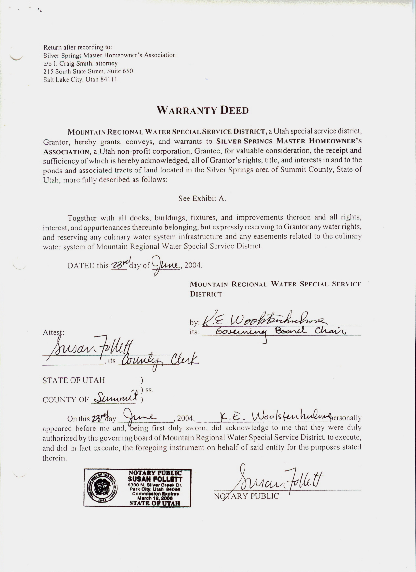
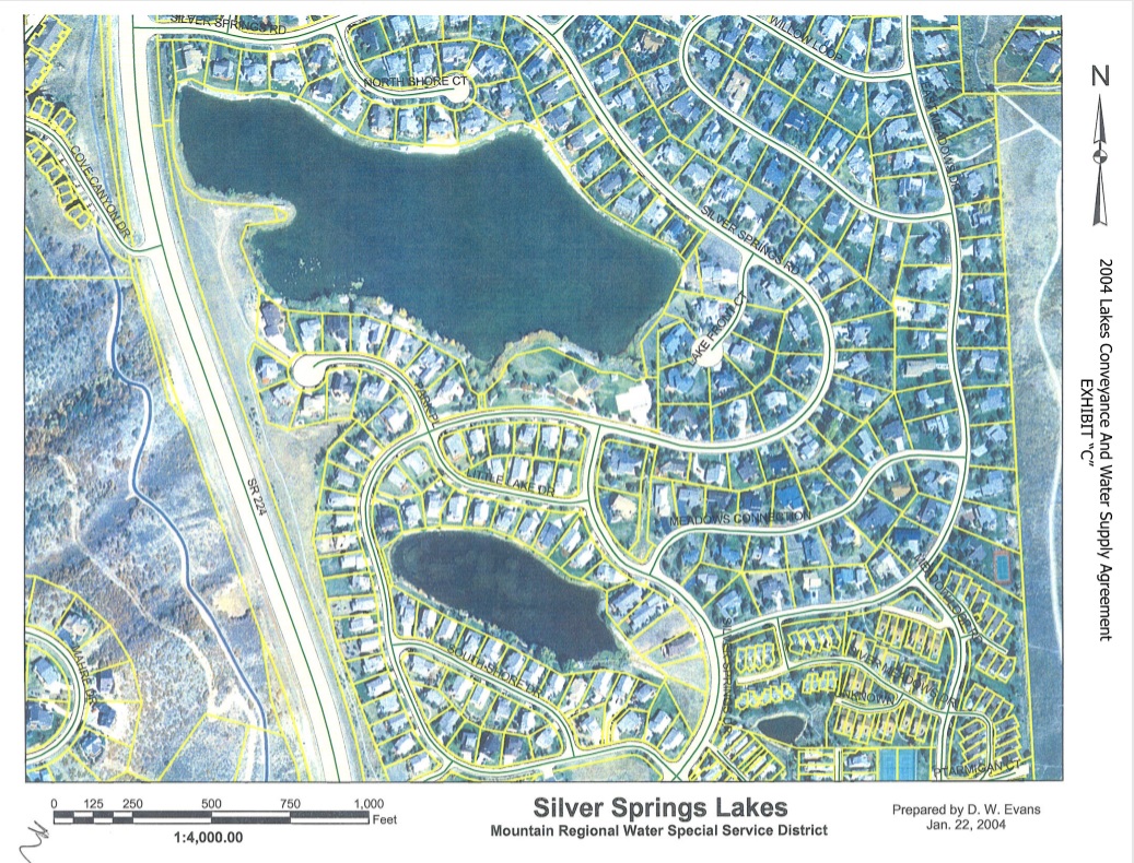
1. Title to the Property. The District has delivered concurrently herewith a warranty deed to the Lakes property identical in form to Exhibit “B” attached hereto and as described in Exhibit “A” for recording in the offices of the Summit County Recorder, reserving to the District, however, all water rights, including water rights associated with the Lakes, any water system infrastructure of the District, and any easements as defined therein related to the water system of the District. A map depicting the Lakes Property is attached hereto as Exhibit “C”. Any modification for any purpose to the Lakes property to be owned by the Association as outlined in this document requires notification and approval of the Association as well as conformance with all applicable federal, state, and local laws, regulations, and ordinances.
2. Provision of Water for Creek and Lakes. The District shall provide the minimum amount of water necessary to keep the Lakes full as set forth below. The District shall provide the water from the following:
(a) The 300 acre-foot storage water right, and the evaporation water right of not to exceed 90 acre-feet annually, approved for the Lakes under Change Application Number a10975 (35-5778).
(b) Enforcement of its contract rights that 6 acre-feet of water is delivered to the Lakes, during the months of July, August, and September, pursuant to the “Agreement” dated January 30, 1998, originally entered into between Summit Water Distribution Company, and the Silver Springs Water Company, to which the District is the successor in interest for Silver Springs Water Company.
(c) The District’s best reasonable efforts to match the six acre-foot obligation of Summit Water Distribution Company during anytime of the year, except in times of drought or other natural causes or unforeseen circumstances such as domestic terrorism, to maintain the level of the Lakes within two feet of exiting the spillway;
(d) The District’s best reasonable efforts to prevent others from diverting water out of Spring Creek Springs or Spring Creek beyond or out of priority of their water right; and
(e) In addition to the water otherwise provided in this agreement, the District will allow overflow water from Spring Creek Springs, not diverted at the Spring Creek Springs collection boxes into the water systems of the District or of the Summit Water Distribution Company, to flow to the Lakes. The District has no obligation to provide a certain quantity of overflow water to the Lakes, but shall permit the overflow water to go into Spring Creek for instream flow purposes into the Lakes so long as the diversion of water into Spring Creek does not jeopardize the ability of the District to provide culinary water to its customers.
(f) The District’s obligations hereunder to provide water to the Lakes so that the Lakes provide a healthy aquatic ecosystem shall be considered and taken into account prior to the District undertaking or accepting additional water service or delivery obligations which would utilize the water source, for the Lakes.
3. Filling of Lakes Each Spring. Except in times or for unforeseen circumstances such as domestic terrorism or if the Lakes are drained either intentionally or through a failure of facility related to the Lake such as the dam or a drain, the District shall, in good faith, use its best efforts to provide sufficient water so that the Lakes are full after April 1 and before June 1 of each year. The Lakes shall be full when the water exits the spillways.
4. Additional Water. If at any time the Association requests additional water for the Lakes beyond what is provided for in this Agreement and if the District has the water available, the District will provide the water upon payment by the Association for the water at the District’s established irrigation rates. In addition, any water pumped out of the Lakes and used by the Association or other residents of Silver Springs shall be metered and shall only be used upon first receiving the District’s permission. The District shall be paid at the District’s established irrigation rates.
5. Standard Operations Plan. In conjunction with Aqua Engineering, the District and the Association shall develop an operating plan, including emergency provisions, for the operation of the Lakes and water delivery. The cost of creating the plan shall be borne by the District. Such plan is attached hereto as Exhibit “D” and incorporated herein by this reference. A Phase I environmental review has been conducted and shall be paid for by the parties each paying one half of the cost of such review.
6. Deferred Maintenance and Remediation. There are deferred maintenance items and remediation improvements required for the Lakes incurred since 2001. These include drainage area cleanup; inspection of outlets; rehabilitation of outlets, spillway structures and valving; excavation of sediment near inlets; removal of vegetation on dams; installation of a flow measuring device, head box and weir; and installation of emergency overflow on lower pond. The District agrees to pay the Association $10.00 (Ten Dollars) and other valuable consideration for all the deferred maintenance and remediation work to be performed. The Association agrees to perform the deferred maintenance and remediation work and to hold the District harmless.
7. Place of Delivery. The District will deliver the water to the Association for the Lakes at a point commonly known as Spring Creek at the Blue Roof building more particularly described in Exhibit “E” attached hereto and incorporated herein by reference. A measuring device sufficient to measure the water delivered to the Lakes shall be installed by the Association at this location. The District shall have the right to approve the type of measuring device and its installation. Both the District and the Association shall have access to and the right to obtain information from this measuring device.
8. Water Delivered. The water delivered by the District under this Agreement shall be:
(a) Delivered in an “as is” condition without warranty as quality.
(b) Not chlorinated or otherwise treated and of the same nature and composition as the water flowing from Spring Creek Springs.
9. The District Will Notify the Association Within 72 Hours After Becoming Aware of Any of the Following Events:
(a) Water quality of water in Spring Creek Springs or Spring Creek discovered in normal testing procedures which would prevent the District from providing such water to its customers for drinking water.
(b) Filing of Change of Applications or proof of beneficial use, installation of infrastructure in Spring Creek Springs or Spring Creek, or water diversion changes made by the District within or upstream of the Lakes.
(c) Other events which may result in a fish kill or render the Lakes unsafe for swimming or other recreational purposes.
10. Association Responsibilities. The Association shall be responsible for:
(a) Establishing community input committees representing Lake interests.
(b) Operating and maintaining control of the Lakes after the District has delivered title to the Association, except that the District shall be responsible for providing the flow of water into the Lakes as provided herein.
(c) Performing the deferred maintenance and remediation work.
(d) Maintaining, operating and controlling the dams.
(e) Carrying comprehensive liability insurance on the Lakes properties in a policy amount with limits of not less than $2,000,000 per occurrence and $1,000,000 per individual for payment of loss, as well as providing the District with an annual certificate of insurance naming the District as an additional insured on the policy. A copy of such initial certificate is attached hereto as Exhibit “F”.
(f) Ensuring proper ecological management of the Lakes, beyond providing the necessary water to which the District agrees to do under Section 2.
(g) Any and all infrastructure, including any subsequent costs related to the Lakes as a water storage facility, except for costs incurred due to the use of the Lakes as a storage facility by the District or for fire suppression, including but not limited to dams, water intake and release gates, meeting any and all necessary State and County requirements and approvals for such a facility.
(h) An Easement to the District to provide any needed access over association property to the Pump Station over by the District and for a 100′ well protection zone.
11. District Requirements. The District shall be responsible for:
(a) Providing water pursuant to the terms of this Agreement. The delivery of water shall be in coordination with the Association as further described in the Standard Operations Plan. A copy of such Plan is attached as Exhibit “D”.
12, Storage Rights and Fire Protection. The Association will allow the District to store the District’s water in the Lakes for any future irrigation system of the District, upon the parties entering into a new Agreement that provides for an anticipated use of the Lakes with a maximum fluctuation of Lake levels from the full condition of the Lakes as described herein, of not more than 2′ during any year, and the District undertaking all costs of such storage use and operation of all facilities for such storage use by the District. The Association further authorized the District and Summit County to use water from the Lakes for fire protection purposes, so long as water used fro that purpose is replaced by the District as soon as reasonably practicable.
13. Release of Claims. The Parties hereby release each other from any and all claims which have or could have arisen as of the date of this agreement related to the transfer of the Lakes from the District to the Association.
14. Indemnification.
(a) Retention of Separate Risks. The Association and the District shall each, separately, be responsible for all damages to persons or property that occur as the result of the negligence or fault of their own individual officers, agents, or employees. The District retains all responsibility and risk for the improvements and acts performed by the District. The Association assumes all responsibility and risk which arise because of its neglect maintenance of the Lakes and improvements and for any changes it negligently makes to the Lakes or improvements after the effective date of this Agreement.
(b) District Indemnification of Association. The District shall indemnify and save the Association free and harmless from all claims that arise as a result of negligence or fault of the District, its officers, agents, or employees. In the event that the Association or any of its officers or employees are named as co-defendants with the District or any of its officers or employees in any civil action based on District responsibilities under the terms of this Agreement, the District agrees to undertake the defense of the Association and any of its officers or employees so named under a reservation of rights, until such time as they have been successfully dismissed from the action or it has been determined by the District that a conflict of interest exists, at which time the Association will be notified of its duty, at its expense, to independently undertake the defense of the Association or its officers or employees named as co-defendants in such civil action.
(c) Association Indemnification of District. The Association shall indemnify and save the District free and harmless from all claims that arise as a result of negligence or fault of the Association, its officers, agents, or employees. In the event that the District or any of its officers or employees are named as co-defendants with the Association or any of its officers or employees in any civil action based on Association responsibilities under the terms of this Agreement, the Association agrees to undertake the defense of the District and any of its officers or employees so named, under reservation of rights agreement, until such times as they have been successfully dismissed from the action or it has been determined by the Association that a conflict of interest exists, at which time the District will be notified of its duty, at its expense, to independently undertake the defense of the District or its officers or employees named as co-defendants in such civil action.
15. Mediation. The parties agree to settle disputes by mutually agreed upon independent mediation.
16. Effective Date, Term, and No Merger Agreement. This Agreement shall be effective upon execution by the parties. The terms of this Agreement shall be perpetual. The responsibilities and obligations herein shall survive the transfer of the Lakes and not be merged into the Deed conveying the Lakes contemplated herein. The parties, however, may amend or terminate this Agreement at any time upon their mutual and written consent.
17. Notices. Any notice provided for or concerning this Agreement shall be in writing and shall be deemed sufficiently given when personally delivered or sent by certified or registered United States mail to the respective address of the District or the Association as set forth below or delivered by confirmed telefax to the telephone numbers listed below:
If sent to the District: Mountain Regional Water Special Service District
Attention: James W. Carbine, Manager
Address: P.O. Box 982320
Address: Park City, UT 84098-2320
Fax: 435-940-1945
With a copy to:………… Summit County Attorney’s Office
P.O. Box 128
Coalville, UT 84017-0128
If sent to the Association:…….Silver Springs Master Homeowners Association
Attention: Robyn Bailey, Manager
Address: 4915 Silver Springs Road
Address: Park City, UT 84098
Fax: 435-649-4033
With a copy to: ……………………J. Craig Smith, Esq.
Smith Hartvigsen, PLLC
215 South State St., Suite 650
Salt Lake City, UT 84111
Each party may change its address or telefax number by written notice in accordance with this paragraph.
18. Governing Law. This Agreement shall be governed by, construed and enforced in accordance with the laws of the State of Utah.
19. Entire Agreement. This Agreement shall constitute the entire agreement between the parties and supersedes any prior understanding, representation, or agreement of the parties regarding the subject matter hereof.
20. Modification of Agreement. Any modification of this Agreement or additional obligation assumed by any party in connection with this Agreement shall be binding only if evidenced in writing signed by each party or an authorized representative of each party.
21. No Waiver. No delay or failure by either party to exercise any right under this Agreement, and no partial or single exercise of that right, shall constitute waiver of that or any other right, unless expressly provided herein. Either party may, by notice delivered in the manner provided in this Agreement, but shall not be under obligation to, waive any of its rights or any conditions hereunder or any covenant or duty of any other party.
22. Person Bound by Agreement. This Agreement shall be binding upon and inure to the benefit of the parties hereto and their respective employees, representatives, successors, and assigns.
23. Attorney Fees. In the event that any action is filed in relation to this Agreement, the substantially successful party in the action shall be entitled, in addition to all other available relief, to recover reasonable attorney fees and costs of litigation.
24. Authorization. Each individual executing this Agreement does thereby represent and warrant to each other so signing (and each other entity for which another person may be signing) that he or she has been duly authorized to sign this Agreement in the capacity and for the entity set forth where he or she signs.
25. Rights and Remedies. The parties shall have all rights and remedies provided under Utah law for a breach or threatened breach of this Agreement, these rights and remedies shall not be mutually exclusive, and the exercise of one or more of these rights and remedies shall not preclude the exercise of any other rights and remedies. Each party confirms that damages at law may be an inadequate remedy for a breach or threatened breach of any provision hereof and the respective rights and obligations of the parties hereunder may be enforceable by specific performance, injunction or other equitable remedy.
26. Necessary Acts and Cooperation. The parties hereby agree to do any act or thing and to execute any and all instruments required by this Agreement and which are necessary and proper to make effective the provisions of this Agreement.
27. Execution of Agreement. This Agreement may be executed in counterparts, each of which shall be deemed an original, but all of which together shall constitute one and the same Agreement. An executed version of this Agreement which has been signed and transmitted by facsimile or other electronic or mechanical means shall be deemed an original.
28. Severability. In the event that any provision herein contained is held to be invalid or void by any court of competent jurisdiction, the same shall be deemed severable from the remainder of this Agreement and shall in no way affect any other provision herein contained. If such provision shall be deemed invalid due to its scope or breadth, such provision shall be valid to the extent of the scope or breadth permitted by law.
29. Incorporation of Exhibits and Recitals. The Exhibits herein and attached hereto and the Recitals set forth between are incorporated in and part of this Agreement as if fully stated in the body of the Agreement.
IN WITNESS THEREOF each party to this Agreement has caused it to be executed on the date indicated below.
SILVER SPRINGS MASTER HOMEOWNERS ASSOCIATION
By: Richard Anthony Sands
Title: President of Silver Springs HOA [Should be written “of the Silver Springs Master HOA]
Date: 5/25/2004MOUNTAIN REGIONAL SPECIAL SERVICE DISTRICT:
acting by and through the Board of County Commissioners of Summit County, Utah, its governing authority,
Name: Ken E. Woolstenhulme
Title: Governing Board Chair
Date: 23 June 2004ATTEST:
Susan Follett
County Clerk
EXHIBIT A
TO WARRANTY DEED
MOUNTAIN REGIONAL WATER SSD/SILVER SPRINGS MASTERS HOAParcel 1 (also known as the “Lower Pond”; also known as Silver Willow Lake; PP-91):
Beginning at a point which is North 2,079.16 feet and East 1,148.18 feet front the Southwest Corner of Section 30, Township I South, Range 4 East, SaIt Lake Base & Meridian, and running
thence North 22° 00′ 00″ West 163.00 feet; thence North 19° 00′ 00″ East 60.00 feet; thence North 82° 00′ 00″ East 1\6.00 feet; thence North 25° 00′ 00″ East 31.00 feet; (hence North 68° 00′ 00″ West 42.00 feet; thence North 86° 00′ 00″ West \68.00 feet;
thence North 8\° 00′ 00″ Wes167.00 feet;
thence North 5\ ° 00′ 00″ West 67.00 feet;
thence North 200 00′ 00″ West \01.00 feel; thence North 2° 00′ 00″ West 179.00 feet; thence North 9° 00′ 00″ East 56.00 feet; thence North 76° 00′ 00″ East 49.00 feet; thence South 65° 00′ 00″ East 81.00 feet; thence South 82° 00′ 00″ East 91.00 feet; thence North 84° 00′ 00″ East 82.00 feet; thence South 82° 00′ 00″ East 72.00 feet; thence South 66° 00′ 00″ East 70.00 feet; thence South 55° 00′ 00″ East 163.00 feet; thence South 71 ° 00′ 00″ East 74.00 feet; thence South 84° 00′ 00″ East 153.00 feet; thence South 88° 00′ 00″ East 95.00 feet; thence North 76° 00′ 00″ East 75.00 feet; thence North 63° 00′ 00″ East 117.92 feet; thence North 81 ° 00′ 00″ East 50.40 feet; thence South 63° 00′ 00″ East 68.00 feet; thence South 36° 00′ 00″ East 194.00 feet; thence South 43° 00′ 00″ East 122.00 feet;thence South 59° 00′ 00″ East 111.00 feet; thence South 63° AD’ 00″ East 161.00 feet; thence South 37° 00′ 00″ East 53.11 feet; thence South 24° 00′ 00″ West 188.34 feet; thence South 38° 00′ 00″ West 105.13 feet; thence South 9° 00′ 00″ East 111.00 feet; thence South 73° 00′ 00″ West 36.00 feet; thence North 64° aD’ 00″ West 57.00 feet; thence North 88° 00′ 00″ West 58.00 feet; thence North 65° 00′ 00″ West 188.00 feet; thence South 77° 00′ 00″ West 108.00 feet; thence South 49° 00′ 00″ West 32.00 feet; thence South 27° 00′ 00″ West 61.00 feet; thence South 46° 00′ 00″ West 69.00 feet; thence South 70° 00′ 00″ West 22.00 feet; thence North 57° 00′ 00″ West 27.00 feet;
thence North 21 ° 00′ 00″ West 101.00 feet;
thence North 60° 00′ 00″ West 176.00 feet; thence North 69° 00′ 00″ West 164.00 feet; thence North 88° 00′ 00″ West 168.00 feet; thence North 83° 00′ 00″ West 91.00 feet;
thence North 51° 00′ 00″ West 98.00 feet to the point of beginning.Containing approximately 20.8208 acres.
Parcel 2 (also known as the “Pump Station on the Lower Pond”; also known as Parcel PP-98-A-1-A):
Beginning at a point which is North 2,346.96 feet and East 1,195.67 feet from the Southwest Corner of Section 30, Township I South, Range 4 East, Salt Lake Base and Meridian (Basis of Bearing being North from the Southwest Corner of Section 31, Township 1 South, Range 4 East, Salt Lake Base and Meridian along the section line to the aforementioned Southwest Corner of Section 30); and running
thence South 68° 00′ 00″ East 42.00 feet; thence South 25° AD’ 00″ West 31.00 feet; thence South 82° AD’ 00″ West 16.00 feet;
thence North 12° 14’45” West 47.13 feet to the point of beginning.Containing approximately 0.02 acres.
Parcel 3 (also known as the “Inlet to the Lower Pond”; also known as Parcel Q)
Beginning at a point on the North Right-of- Way line of Silver Springs Road, said point being North 1,695.167 feet and East 1,850.961 feet from the Southwest Comer of Section 30, Township I South, Range 4 East, Salt Lake Base and Meridian; and running
thence North 4° 00′ 00″ West 49.925 feet; thence North 70° 00′ 00″ East 20.806 feet;
thence South 4° 00′ 00″ East 53.921 feet to said North Right-of- Way line of Silver Springs Rd, also being on an 8 18.83 foot radius curve to the left (radius point bears South 8° 16′ 06″ East);
thence Westerly along said curve 20.075 feet to the point of beginning.Containing approximately 0.02 acres.
Parcel 4 (known as the “Upper Pond”, also known as Silver Willow Pond or Duck Pond; Parcel PP-98-A-6):
Beginning at a point which is North 1,257.42 feet and East 1,538.00 feet from the Southwest Corner of Section 30. Township 1 South, Range 4 East, Salt Lake Base and Meridian, and running
thence North 52° 00′ 00″ East 91.53 feet;
thence North 81 ° 00′ 00″ East 115.00 feet;
thence South 87° 00′ 00″ East 153.00 feet; thence South 70° 00′ 00″ East 103.00 feet; thence South 58° 00′ 00″ East 112.00 feet; thence South 53° 00′ 00″ East 94.00 feet; thence South 73° 00′ 00″ East 65.00 feet; thence South 62° 00′ 00″ East 60.63 feet; thence South 1° 00′ 00″ West 72.17 feet;
thence South 38° 00′ 00″ East 160.00 feet;
thence South 51 ° 00′ 00″ East 124.00 feet;
thence South 33° 00′ 00″ West 42.00 feet;
thence North 68° 00′ 00″ West 121.00 feet; thence North 81 ° 00′ 00″ West 68.00 feet; thence South 83° 00′ 00″ West 98.00 feet; thence South 50° 00′ 00″ West 38.00 feet; thence South 27° 00′ 00″ West 70.00 feel; thence North 74° 00′ 00″ West 38.00 feet; thence North 5° 00′ 00″ West 94.00 feet;
thence North 4 1° 00′ 00″ West 38.00 feet;thence North 61 ° 00′ 00″ West 120.00 feet; thence North 66° 00′ 00″ West 182.00 feet; thence North 60° 00′ 00″ West 208.35 feet to a point on an 865.947 foot radius curve to the left (radius point bears South 77° 01′ 56″ West);
thence along said curve 52.12 feet through a central angle of3 ° 26′ 56″;
thence North 16° 25′ 00″ West 69.82 feet to the point of beginning.Containing approximately 5.391 acres.
Excepting therefrom that portion of the above described property lying within the bounds of the following:
Beginning at a point which is North 874.95 feet and East 2,047.53 feet from the Southwest Corner of Section 30, Township I South, Range 4 East, Salt Lake Base and Meridian (Basis of Bearing being North from the Southwest Corner of Section 31, Township I South, Range 4 East, Salt Lake Base and Meridian, along the section line to the aforementioned Southwest Corner of Section 30); and running
thence South 80° 41′ I ]” East I 07.02 feet;
thence South 50° 00′ 00″ West 38.00 feet;
thence South 27° 00′ 00″ West 70.00 feet; thence North 74° 00′ 00″ West 38.00 feet;
thence North 05° 00′ 00″ West 94.00 feet to the point of beginning.Also,
Excepting therefrom that portion of the above described property lying within the bounds of the following:
Beginning at a point which is North 874.95 feet and East 2,047.53 feet from the Southwest Corner of Section 30, Township I South, Range 4 East, Salt Lake Base and Meridian (Basis of Bearing being North from the Southwest Corner of Section 31, Township I South, Range 4 East, Salt Lake Base and Meridian, along the section line to the aforementioned Southwest Corner of Section 30); and running
thence South 80° 41′ II” East 38.58 feet to a point on the boundary of the SouthShore Silver Springs Subdivision Plat C, as recorded;
thence North 61 ° 00′ 00″ West 72.03 feet along said subdivision boundary;
thence South 4\ ° 00′ 00″ East 38.00 feet to the true point of beginning.The following is shown for informational purposes only: Tax Parcel No’s. PP-98-A-\ 0 (affects Parcels I
& 2), PP-98-A-I-A & PP-98-A-6.WARRANTY DEED – EXHIBIT “B”
EXHIBIT “C”
2004 Lakes Conveyance and Water Supply Agreement Map Exhibit C
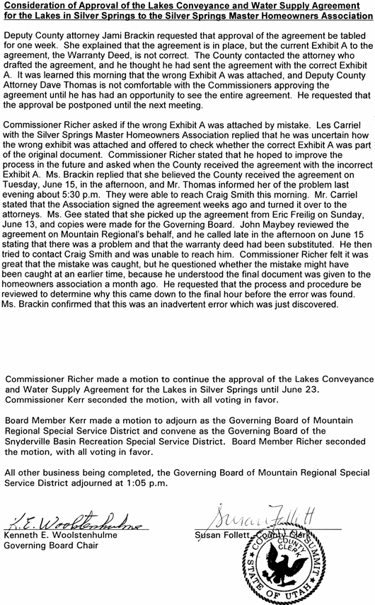
2004 July 13 – J. Craig Smith Letter and Warranty Deed to Summit County Recorder Alan Springs
[These minutes are available at the office of the Summit County Clerk]
Summit County Commission June 10, 2004 Meeting Minutes
MRW Special Service District – June 10, 2004
[These minutes are available at the office of the Summit County Clerk]
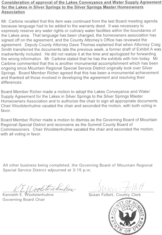
Summit County Commission June 23, 2004 Meeting Minutes
MRW Special Service District – June 23, 2004
—{The above agreement and documents were given to Lucy Archer by Summit County Clerk Ken Jones on Friday, July 25, 2008. He was alone in his office as his staff were out enjoying an extended weekend between Pioneer Day on Thursday, July 24th and the weekend.]—
2009 May 18 – “MA Minutes Item 5.e.3 “3) Lake Agreement / Affidavit: Our HOA counsel recommends that Robyn complete an affidavit about all HOAs agreeing to the signing of the agreement receiving the Lakes from Mt. Regional. Robyn will do this. Item continued”
2009 June 15 – “MA Minutes Item 5.f. Lakes Acquisition Affidavit: Robyn will draft it.”
2009 July 21 – “MA Minutes Item 5.f.k. Lakes acquisition affidavit: Robyn has finished the affidavit it just needs to be notarized. Item continued.”
2009, August 18 – “MA Minutes Item 4.g. Lakes Acquisition Affidavit: The Secretary will have the document notarized. Item continued.
2009, September 29 – “MA Minutes Item 8.h. Lakes Acquisition Affidavit: Robyn needs to complete. Item Continued.”
2009, October 20 -“MA Minutes Item 5.c. Lakes Acquisition Affidavit: Robyn has finished this and turned it over to Bill Noland. Item Closed.”
Bailey’s affidavit states that Sands in early 2004 required all the Homeowners Association board presidents to sign a lake agreement approving acquisition by the Master Association of the “lakes” properties from Mountain Regional for recreational use by Master Association members before he signed the Lake Conveyance Agreement with Mountain Regional Water. The problem is that no one can find a copy of the SSMA board’s 2004 Lakes Conveyance and Water Supply Agreement Exhibit C lakes pre-agreement said to be signed by all the Master Association board members. Bailey lists the board members on the affidavit. We contacted these board members to ascertain if any of them had a copy or remembered signing such a letter, a letter that has never before, during six years, been mentioned by anyone on any recorded Minutes, etc. Three of the named board members responded that they never heard of such a letter and certainly never signed it. Rick Hovey was angry to learn of this document and said there better not be anyone out there signing his name on this and any other document without his knowledge.
Board Members have stated that Robyn did not notify all the member subdivisions to attend the 2004 meeting when this Agreement was purportedly to be discussed and that not all the member subdivision boards were represented (no quorum?). Anthony Sands stated at this time and again on February 9, 2010 that if he had known that all the individual subdivisions were not in support or agreement of this conveyance that he would never have signed it. A copy of this affidavit was requested from Noland but he has never responded. The copy linked above was provided by another party.
[3/20/2010] …If you read Bailey’s Affidavit literally, you will note that she swears and affirms….”obtain the signatures” etc. The sentence is missing key words, it does not say whether she was asked to obtain, was going to obtain, would have liked to obtain, it was discussed that she obtain the signatures. It is wide open. After making a request of the stated signers to confirm they signed the affidavit, those that responded denied they ever signed either document. Some folks think this affidavit was too little too late. A 2009 ploy to cover-up another 2004 Master Association board power grab without Homeowner approval?